Kiryat Ye'arim
Kiryat Ye'arim
|
|
|---|---|
| Hebrew transcription(s) | |
| • ISO 259 | Qiryat Yˁarim |
| • Also spelled | Kiryat Yearim (unofficial) |

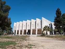
Beth midrash in Kiryat Ye'arim
|
|
| Coordinates: 31°48′13.53″N 35°6′9.03″E / 31.8037583°N 35.1025083°ECoordinates: 31°48′13.53″N 35°6′9.03″E / 31.8037583°N 35.1025083°E | |
| District | Jerusalem |
| Government | |
| • Type | Local council |
| • Head of Municipality | Avraham Rozental |
| Population (2015) | |
| • Total | 3,936 |
| Name meaning | Town of forests |
Kiryat Ye'arim (Hebrew: קִרְיַת יְעָרִים), also known as Telz-Stone, is an ancient place mentioned in the Bible and the modern site of an ultra-Orthodox town in the Jerusalem District of Israel. It is bordered on one side by the Arab village of Abu Ghosh, and on the other side by the secular community of Neve Ilan. In 2015 it had a population of 3,936
According to the Israel Central Bureau of Statistics (CBS), at the end of 2005 Kiryat Ye'arim had a population of 3,100, predominantly Jewish, with a growth rate of 1.2%. Many of the residents are immigrants from North America, Europe and South Africa.
Kiryat Ye'arim is located approximately 10 kilometres (6.2 mi) west of Jerusalem, just north of the Tel Aviv – Jerusalem highway. Neighboring Kiryat Ye'arim to the northeast is the Arab town of Abu Ghosh. Kiryat Ye'arim is between 661.8 and 749.5 meters above sea level.
Kiryat Ye'arim is home to three Orthodox post-high school yeshivas aimed at foreign students, particularly from the U.S.: Neveh Zion, Keser Dovid and Yishrei Lev
...
Wikipedia

