Kinzie Street railroad bridge
| Kinzie Street railroad bridge | |
|---|---|

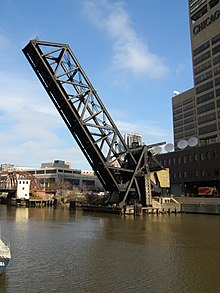
Kinzie Street railroad bridge permanently locked in the raised position
|
|
| Coordinates | 41°53′18.7″N 87°38′21″W / 41.888528°N 87.63917°WCoordinates: 41°53′18.7″N 87°38′21″W / 41.888528°N 87.63917°W |
| Crosses | Chicago River |
| Locale | Chicago |
| Official name | Chicago & North Western Railway, Kinzie Street drawbridge |
| Other name(s) | Carroll Avenue bridge |
| Heritage status | Chicago Landmark |
| Characteristics | |
| Design | bascule bridge |
| Total length | 195.83 feet (59.69 m) |
| Width | 41.7 feet (12.7 m) |
| Longest span | 170 feet (52 m) |
| History | |
| Construction begin | December 1907 |
| Opened | September 19, 1908 |

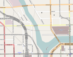
Area map showing the location of the bridge just to the south of Kinzie Street
|
|
The Chicago and North Western Railway's Kinzie Street railroad bridge (also known as the Carroll Avenue bridge) is a single leaf bascule bridge across the north branch of the Chicago River in downtown Chicago, Illinois. At the time of its opening in 1908 it was the world's longest and heaviest bascule bridge. Previous bridges on the same site included the first bridge to cross the Chicago River, Chicago's first railroad bridge, and one of the first all-steel bridges in the United States.
The Chicago Sun-Times, the last railroad customer to the east of the bridge, moved their printing plant out of downtown Chicago in 2000, and the bridge has been unused since. It was designated a Chicago Landmark in 2007.
Kinzie Street railroad bridge is located at 41°53′18.7″N 87°38′21″W / 41.888528°N 87.63917°W, it runs in an east-west orientation, spanning the north branch Chicago River between the Near North Side and Near West Side community areas of Chicago. To the south is the historic area of Wolf Point at the confluence of the main stem of the Chicago River with the north and south branches, and to the east is 350 West Mart Center and Merchandise Mart. The railroad track across the bridge is a spur line of the Union Pacific Railroad, that branches off from the route of the Union Pacific/North Line about 1 mile (1.6 km) north-west of the bridge. The railroad to the east of the bridge has been abandoned since 2000.
...
Wikipedia
