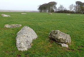
Kingston Russell Stone Circle

View across the western half of the circle
|
|
| Location | Kingston Russell |
|---|---|
| Coordinates | 50°41′19″N 2°35′56″W / 50.688526°N 2.598998°W |
| Type | Stone circle |
| History | |
| Periods | Neolithic / Bronze Age |
Kingston Russell Stone Circle, also known as the Gorwell Circle, is a stone circle located between the villages of Abbotsbury and Littlebredy in the south-western English county of Dorset. Archaeologists believe that it was likely erected during the Bronze Age. The Kingston Russell ring is part of a tradition of stone circle construction that spread throughout much of Britain, Ireland, and Brittany during the Late Neolithic and Early Bronze Age, over a period between 3,300 and 900 BCE. The purpose of such monuments is unknown, although archaeologists speculate that they were likely religious sites, with the stones perhaps having supernatural associations for those who built the circles.
A number of these circles were built in the area around modern Dorset, typically being constructed from sarsen stone and being smaller than those found elsewhere. The Kingston Russell ring is the largest of those in Dorset, measuring 24 by 27 metres (79 feet by 89 feet) in diameter and containing eighteen sarsen stones arranged in an oval shape. The site has not been excavated or been subject to in-depth archaeological investigation.
Positioned at the national grid reference 35770878, Kingston Russell Stone Circle is located on a chalk ridge that is west of Portesham, overlooking Abbotsbury and the sea. The site is located on open downland at a height of 189 metres (620 feet) above sea level. The historic house of Kingston Russell is about 1.6 kilometres to the north. The ruined burial chamber known as The Grey Mare and her Colts is a short distance to the southeast.
...
Wikipedia

