Kingston Bagpuize
| Kingston Bagpuize | |
|---|---|
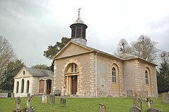
 St. John the Baptist parish church |
|
| Kingston Bagpuize shown within Oxfordshire | |
| Population | 1,955 (parish, with Southmoor) (2001 census) |
| OS grid reference | SU4098 |
| Civil parish | |
| District | |
| Shire county | |
| Region | |
| Country | England |
| Sovereign state | United Kingdom |
| Post town | Abingdon |
| Postcode district | OX13 |
| Dialling code | 01865 |
| Police | Thames Valley |
| Fire | Oxfordshire |
| Ambulance | South Central |
| EU Parliament | South East England |
| UK Parliament | |
| Website | Kingston Bagpuize with Southmoor |
Kingston Bagpuize /ˈkɪŋstən ˈbæɡpjuːz/ is a village in the civil parish of Kingston Bagpuize with Southmoor, about 6 miles (10 km) west of Abingdon. It was part of Berkshire, England until the 1974 boundary changes transferred it to Oxfordshire.
The village is next to the junction of the A420 (Oxford – Swindon) and A415 (Abingdon – Witney) main roads. It is contiguous with Southmoor village to the west and about 1 mile (1.6 km) southeast of Longworth village.
The toponym Kingston Bagpuize is derived from the village's original name Kingston plus the surname of Ralph de Bachepuz, a Norman nobleman from Bacquepuis in Normandy who aided William of Normandy in the Norman conquest of England in 1066.
...
Wikipedia

