King Island (Tasmania)
 |
|
| Location of King Island in Tasmania | |
| Etymology | Philip Gidley King |
|---|---|
| Geography | |
| Location | Roaring Forties, Great Australian Bight and Bass Strait |
| Coordinates | 39°52′S 143°59′E / 39.867°S 143.983°ECoordinates: 39°52′S 143°59′E / 39.867°S 143.983°E |
| Archipelago | New Year Group |
| Area | 1,098 km2 (424 sq mi) |
| Area rank | 3rd in Tasmania |
| Highest elevation | 162 m (531 ft) |
| Highest point | Gentle Annie |
| Administration | |
|
Australia
|
|
| State | Tasmania |
| LGA | Municipality of King Island |
| Largest settlement | Currie |
| Demographics | |
| Population | 1800 (June 2013) |
| Pop. density | 1.50 /km2 (3.88 /sq mi) |
| Additional information | |
| Official website | kingisland |
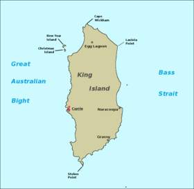
The King Island, part of the New Year Group, is one of the islands that make up the state of Tasmania, Australia. It is located in the Roaring Forties and forms part of the official land divide between the Great Australian Bight and Bass Strait, off the north-western tip of the main island of Tasmania, about halfway between Tasmania and the mainland state of Victoria. The southernmost point is called Stokes Point and the northernmost point is called Cape Wickham. There are three small islands surrounding King Island, namely New Year Island and Christmas Island situated to the northwest, and a smaller island called Councillor Island to the east.
King Island was named after Philip Gidley King, Colonial Governor of New South Wales, whose territory at the time included what is now Tasmania. The local government area of the island is King Island Council. The population as at the 2011 census was 1,566.
Captain Reed was the first European to discover King Island in 1799 while hunting seals in the schooner Martha. Matthew Flinders’ first map of Van Diemen's Land and the Bass Strait, which was sent to England (before Flinders had left) and was published in June 1800, did not show King Island. However, before Flinders left Sydney for England in 1800, Reed had informed Flinders of the existence of the island. Flinders’ second map of Van Diemen's Land and Bass's Strait (properly finished en route to England) and published with his Observations in 1801 shows:
...
Wikipedia

