Kimballton, Iowa
| Kimballton, Iowa | |
|---|---|
| City | |
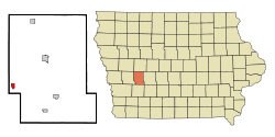
 Location of Kimballton, Iowa |
|
| Coordinates: 41°37′42″N 95°4′28″W / 41.62833°N 95.07444°WCoordinates: 41°37′42″N 95°4′28″W / 41.62833°N 95.07444°W | |
| Country |
|
| State |
|
| County | Audubon |
| Area | |
| • Total | 0.77 sq mi (1.99 km2) |
| • Land | 0.77 sq mi (1.99 km2) |
| • Water | 0 sq mi (0 km2) |
| Elevation | 1,293 ft (394 m) |
| Population (2010) | |
| • Total | 322 |
| • Estimate (2016) | 295 |
| • Density | 418/sq mi (161.5/km2) |
| Time zone | Central (CST) (UTC-6) |
| • Summer (DST) | CDT (UTC-5) |
| ZIP code | 51543 |
| Area code(s) | 712 |
| FIPS code | 19-41295 |
| GNIS feature ID | 0458078 |
Kimballton is a city in Audubon County, Iowa, United States. The population was 322 at the 2010 census.
Kimballton was founded in 1883 when Hans Jensen Jorgensen opened a post office at the site. The town was officially established in 1888, and incorporated in 1908. The town is named for a railroad employee, Edward Kimball.
There are eight sites in or near Kimballton listed on the National Register of Historic Places.
Kimballton is located at 41°37′42″N 95°4′28″W / 41.62833°N 95.07444°W (41.628280, -95.074492).
According to the United States Census Bureau, the city has a total area of 0.77 square miles (1.99 km2), all of it land.
Kimballton lies 3 miles (4.8 km) north of Elk Horn, 13 miles (21 km) east of Harlan, and roughly 60 miles (roughly 95 km) east of Omaha.
As of the census of 2010, there were 322 people, 145 households, and 95 families residing in the city. The population density was 418.2 inhabitants per square mile (161.5/km2). There were 157 housing units at an average density of 203.9 per square mile (78.7/km2). The racial makeup of the city was 97.8% White, 0.3% Native American, 0.9% Asian, 0.3% from other races, and 0.6% from two or more races.
...
Wikipedia
