Kilakarai
|
Kilakarai கீழக்கரை Keelai |
|
|---|---|
| Town | |

|
|
| Location in Tamil Nadu, India | |
| Coordinates: 9°13′53″N 78°47′04″E / 9.23135°N 78.7844°ECoordinates: 9°13′53″N 78°47′04″E / 9.23135°N 78.7844°E | |
| Country |
|
| State | Tamil Nadu |
| District | Ramanathapuram |
| Taluka | Kilakarai |
| Government | |
| • Type | Municipality |
| • Body | Kilakarai Municipality |
| Elevation | 8 m (26 ft) |
| Population (2011) | |
| • Total | 38,355 |
| Demonym(s) | Kilakaraian |
| Languages | |
| • Official | Tamil |
| Time zone | IST (UTC+5:30) |
| PIN | 623 517 |
| Telephone code | 91 4567 |
| Vehicle registration | TN 65 |
| Distance from Chennai | 558 kilometres (347 mi) S |
| Distance from Bengaluru | 539 kilometres (335 mi) S |
| Distance from Madurai | 132 kilometres (82 mi) E |
| Distance from Ramanathapuram | 18 kilometres (11 mi) S |
| Distance from Coimbatore | 365 kilometres (227 mi) W |
| Distance from Tuticorin | 121 kilometres (75 mi) N |
| Distance from Adirampattinam | 152 kilometres (94 mi) S |
| Climate | BSh (Köppen) |
| Precipitation | 909 millimetres (35.8 in) |
| Avg. summer temperature | 30 °C (86 °F) |
| Avg. winter temperature | 25 °C (77 °F) |
Kilakarai, Kilakkarai or Keelakarai (Tamil: கீழக்கரை) is a municipality in Ramanathapuram district in the Indian state of Tamil Nadu. As of 2011, the town had a population of 38,355. Kilakarai is one of the Taluka in Ramanathapuram District.
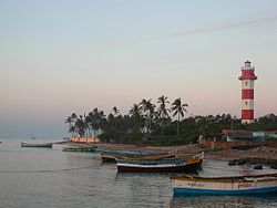
Kilakarai is an ancient coastal town and a port, located in the southern Tamil Nadu. It was a flourishing sea port and a gateway to places as far as Madurai until the early 20th century. The famous pearl belt known as the Gulf of Mannar in the Bay of Bengal is dotted with small islands Appa Tivu, Nallathanni Theevu, Shuli Tivu,Uppu Tanni Tivu, Talari Tivu and Musal Tivu. The coastal line of Kilakarai is formed by series of small bays and finest coral reefs sheltering the town from the perils of the ocean. It was also called as "Kelikkarai", "Ninathaan mudithaan pattinam", "Sembi Nadu", "lebbat pattan" (pattan mentioned in voyages of Ibn Battuta & map displayed in Ibn Battuta Mall).
The prime occupations of the people were pearl, conch, sea trade and transport. The mid-20th century saw a decline in the occupations of the people of Kilakarai, with the advent of the surface transport the Merchant Navies faded away and Kilakarai aka Killikare ceased to be a harbour and port. The cultured pearl industry and the mindless dragnet fishing that destroyed the coral reefs, choked the once robust pearl trade or Muthu Salabam. The conch and coral industries declined due to new regulations and restrictions.
Kilakarai is renowned for its communal harmony. The majority of the population here is Muslim with people of other faith Hindu, Christians living together. The communal harmony that always existed is best exemplified by the famous Rameswaram temple and Jumma Pallivasal (Vallal Seethakathi is interred here) at Kilakarai, while the architecture is the same the workforce was provided by the erstwhile ruler mannan SETHUPATHI of Ramnad and most of the materials for both the edifice were supplied by the Kilakarai merchant navies. The town is reminiscent of Spanish Moorish architecture and is located about 60 km south west of the temple town of Rameswaram.
...
Wikipedia

