Khulna Division
|
Khulna Division খুলনা বিভাগ |
||
|---|---|---|
| Division of Bangladesh | ||
|
||
 Location of Khulna in Bangladesh |
||
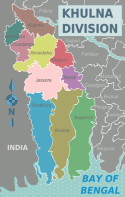
 Districts of Khulna Division |
||
| Coordinates: 22°55′N 89°15′E / 22.917°N 89.250°ECoordinates: 22°55′N 89°15′E / 22.917°N 89.250°E | ||
| Country |
|
|
| Capital | Khulna | |
| Area | ||
| • Total | 22,284.22 km2 (8,603.99 sq mi) | |
| Population (2011 census) | ||
| • Total | 15,687,759 | |
| • Density | 700/km2 (1,800/sq mi) | |
| Time zone | BST (UTC+6) | |
| ISO 3166 code | BD-D | |
Khulna Division (Bengali: খুলনা বিভাগ) is one of the seven divisions of Bangladesh and is in the south-west of the country. It had an area of 22,285 km2 and a population of 15,563,000 at the 2011 Census (preliminary returns). Its headquarters is Khulna city in Khulna District.
The Khulna division borders the Indian state of West Bengal to the west, the Rajshahi Division to the north, the Dhaka and Barisal Divisions to the east, and has a coastline on the Bay of Bengal to the south. It is part of the Ganges River delta or Greater Bengal Delta. Other rivers include the Madhumati River, the Bhairob River and the Kopotokkho River. The region also includes several islands in the Bay of Bengal.
The division was formed in 1960. Khulna Division consists of the following ten districts (zilas), subdivided into 59 sub-districts (upazilas):
Khulna was the backbone of the East Pakistan's main foreign currency earner, the jute industry. There are many large jute mills in Khalishpur near Khulna city processing jute fiber, besides the other heavy industries like Khulna News Print Mills and Khulna Hardboard Mills. The country's second seaport, Mongla Port, and the country's only ship building yard is in Khulna division.
The largest mangrove forest in the world — the Sundarban — is spread over the three most southerly districts of Satkhira, Khulna and Bagherhat.
...
Wikipedia

