Keystone, West Virginia
| Keystone, West Virginia | |
|---|---|
| City | |

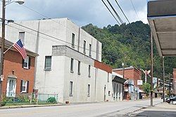
U.S. Route 52 in the city's southwest
|
|
| Coordinates: 37°24′54″N 81°26′46″W / 37.41500°N 81.44611°WCoordinates: 37°24′54″N 81°26′46″W / 37.41500°N 81.44611°W | |
| Country | United States |
| State | West Virginia |
| County | McDowell |
| Government | |
| • Mayor | Dennis Robertson |
| Area | |
| • Total | 0.32 sq mi (0.83 km2) |
| • Land | 0.32 sq mi (0.83 km2) |
| • Water | 0 sq mi (0 km2) |
| Elevation | 1,631 ft (497 m) |
| Population (2010) | |
| • Total | 282 |
| • Estimate (2015) | 252 |
| • Density | 881.3/sq mi (340.3/km2) |
| Time zone | Eastern (EST) (UTC-5) |
| • Summer (DST) | EDT (UTC-4) |
| ZIP code | 24852 |
| Area code(s) | 304 |
| FIPS code | 54-43516 |
| GNIS feature ID | 1554871 |
| Website | City of Keystone |
Keystone is a city in McDowell County, West Virginia, United States. The population was 282 at the 2010 census. Keystone is one of several municipalities in West Virginia with an African-American majority, with 65 percent of the residents being black.
Larry Scott Deaner wrote about the historical geography of the African-American population of Keystone in his 2004 Master's thesis. Deaner calls Keystone the cultural capital of the "Free State of McDowell" - a term coined by Matthew Thomas Whittico, a local newspaper editor and community leader from Keystone in the early 20th century. Keystone possessed a unique combination of political, social, and economic characteristics that made it an attractive place for African-Americans to migrate to in the late 1800s and early 1900s.
Keystone was founded in 1892 by the Keystone Coal & Coke Company. Keystone was then incorporated in 1909 by the Circuit Court of McDowell County. Its name is derived from the name of the coal and coke company operating at that point. The city was formerly known as Cassville.
Denise Giardina modeled the fictional town of Annadel in her novel Storming Heaven after Keystone.
According to the United States Census Bureau, the city has a total area of 0.32 square miles (0.83 km2), all of it land.
As of the census of 2010, there were 282 people, 122 households, and 74 families residing in the city. The population density was 881.3 inhabitants per square mile (340.3/km2). There were 183 housing units at an average density of 571.9 per square mile (220.8/km2). The racial makeup of the city was 34.4% White, 65.2% African American, and 0.4% Asian. Hispanic or Latino of any race were 0.7% of the population.
...
Wikipedia


