Kew Gardens Hills, Queens
| Kew Gardens Hills | |
|---|---|
| Neighborhood in Queens | |

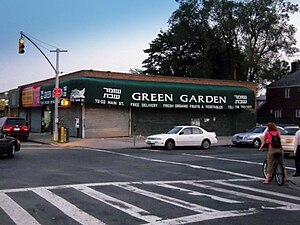
A fruit and vegetable store on Main Street in Kew Gardens Hills.
|
|
| Country | United States |
| State | New York |
| County | Queens |
| Named for | Kew Gardens, Queens; in turn named after Royal Botanic Gardens, Kew |
| Area | |
| • Total | 1.0 sq mi (3 km2) |
| Population (2000) | |
| • Total | 38,216 |
| Ethnicity | |
| • White | 85.1% |
| • Black | 1.2% |
| • Hispanic | 4.2% |
| • Asian | 8.5% |
| • Other | 1.% |
| Economics | |
| • Median income | $95,847 |
| ZIP code | 11367 |
| Area code(s) | 718, 347, 917 |
Kew Gardens Hills is a middle class neighborhood in the middle of the New York City borough of Queens.
Kew Gardens Hills is situated in the southwestern corner of the area historically known as the Town of Flushing, in its 6th district.
As neighborhoods in the City of New York are not designated by the city, there are multiple means to determine the geographical boundaries of the area:
Adjacent neighborhoods include Forest Hills to the west, Hillcrest to the east, Briarwood to the south, and Queensboro Hill to the north.
In the northwestern part of the neighborhood was the location of the 120 acres (49 ha) Spring Hill Farm. The farm was part of the Francis Lewis estate during colonial times. By 1762 the farm was owned by Colonel Thomas Willet, High Sheriff of Flushing, and was sold to Cadwallader Colden, lieutenant governor for the Province of New York. In 1763 Colden built the Spring Hill House on the property. In 1783 the property was confiscated by the government because Cadwallader's son David was a loyalist to the monarchy. By 1894 the Durkee family owned the property and sold it to the Cedar Grove Cemetery Corporation. The Spring Hill House became the office of the Cedar Grove Cemetery, until the house was later destroyed by a fire.Cadwallader Colden and Thomas Willet are among those who are buried on the property on what is now the grounds of the Mount Hebron Cemetery.
In the 19th century the area of Kew Gardens Hills was known as Head of the Fly, for its location at the headwaters of the Flushing Creek (or Flushing River). Fly or vly, being the Dutch word for swamp. One of the oldest roads through the area was called the Vleigh Road, and still exists today as Vleigh Place.
...
Wikipedia
