Kesennuma
|
Kesennuma 気仙沼市 |
|||
|---|---|---|---|
| City | |||

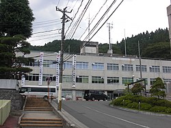
Kesennuma City Hall
|
|||
|
|||
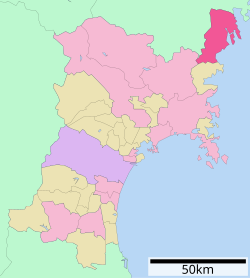
 Location of Kesennuma in Miyagi Prefecture |
|||
| Coordinates: 38°54′29″N 141°34′11.3″E / 38.90806°N 141.569806°ECoordinates: 38°54′29″N 141°34′11.3″E / 38.90806°N 141.569806°E | |||
| Country | Japan | ||
| Region | Tōhoku | ||
| Prefecture | Miyagi | ||
| Government | |||
| • -Mayor | Noboru Suzuki | ||
| Area | |||
| • Total | 332.44 km2 (128.36 sq mi) | ||
| Population (September 2015) | |||
| • Total | 65,434 | ||
| • Density | 197/km2 (510/sq mi) | ||
| Time zone | Japan Standard Time (UTC+9) | ||
| - Tree | Japanese Black Pine | ||
| - Flower | Azalea | ||
| - Bird | Seagull | ||
| - Fish | Bonito | ||
| Phone number | 0226-22-6600 | ||
| Address | 1-1-1 Yōka-machi, Kesennuma-shi 988-8501 | ||
| Website | Official website | ||
Kesennuma (気仙沼市 Kesennuma-shi?) is a city in Miyagi Prefecture, in the Tohoku region of northern Japan. As of September 2015, the city had an estimated population of 65,434 and a population density of 197 inhabitants per square kilometre (510/sq mi). The total area is 332.44 square kilometres (128.36 sq mi). Large sections of the city were destroyed by the 2011 Tōhoku earthquake and tsunami and major fires on March 11, 2011.
Kesennuma is in the far northeastern corner of Miyagi Prefecture. The city wraps around the western part of Kesennuma Bay and also includes the island of Ōshima. Its coastline forms the southern boundary of the Sanriku Fukkō National Park, which stretches north to Aomori Prefecture.
The city borders Hirota Bay, Kesennuma Bay, and the Pacific Ocean to the east and Minamisanriku, Miyagi to the south. Iwate Prefecture makes up the remainder of its borders, with the city Ichinoseki to the west, and the city of Rikuzen-Takata to the north. The highest point in Kesennuma is 711.9 metres (2,336 ft) high, on the border with Motoyoshi, while the lowest point is at sea level. The Ōkawa River flows through the city and into Kesennuma Bay.
Kesennuma is situated in a temperate climate zone and has a moderate climate. The city's average temperature is 10.8 °C (51.4 °F) and its average annual precipitation is 1,370.6 mm (53.96 in). Its record high is 36.0 °C (96.8 °F) on August 15, 1994, and its record low is −12.6 °C (9.3 °F) on February 17, 1980. The city's climate is fairly similar to Sendai, the largest city in Miyagi Prefecture. Since Kesennuma is north of Sendai, it is naturally slightly cooler. However, Kesennuma is known to be fairly warm for a city at its latitude, largely because of ocean currents.
...
Wikipedia


