Kerrobert, Saskatchewan
| Kerrobert | |
|---|---|
| Town | |

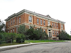
Kerrobert Court House
|
|
| Location of Kerrobert in Saskatchewan | |
| Coordinates: 51°55′12″N 109°07′38″W / 51.92000°N 109.12722°W | |
| Country | Canada |
| Province | Saskatchewan |
| Village | 1906 |
| Post Office established: | 1910 |
| Town | 1911 |
| Government | |
| • Mayor | Wayne Mock |
| • MLA Kindersley | Bill Boyd |
| • MP Battlefords—Lloydminster | Gerry Ritz |
| Area | |
| • Total | 7.49 km2 (2.89 sq mi) |
| Population (2011) | |
| • Total | 1,061 |
| • Density | 141.7/km2 (367/sq mi) |
| Time zone | Central Standard Time (UTC−6) |
| Postal code | S0L 1R0 |
| Highways |
|
| Website | Town of Kerrobert website |
Kerrobert is a town in west central Saskatchewan. It had 1,061 residents in 2011.
Kerrobert is served by Highway 21, Highway 31 and Highway 51 as well as the Canadian Pacific Railway. It is approximately 65 kilometres east of the Saskatchewan/Alberta border and 180 kilometres west of Saskatoon.
The town is known for its large water tower, clearly visible from 15 kilometres away.
The village began with the name of Harlsberg in 1906 which became Kerr-Robert in 1910 with a final name change in 1924 to Kerrobert.
Kerrobert is home to several historic buildings including the Kerrobert Water Tower (1914), the Kerrobert Library (1910) and the Kerrobert Court House
Kerrobert Court House, located in the centre of the town, was built in 1920. It was designed by the Provincial Architect Maurice W. Sharon and built by Wilson and Wilson of Regina for $145,750. The brick and stone structure was the seat of the Kerrobert Judicial District. The former courthouse is currently used as the Town of Kerrobert Municipal office.
Kerrobert’s first rink was built in 1910. A tin covered structure was built in 1911 on the 400 block of Manitoba Ave. The arena was used by citizens of the Kerrobert area until it was destroyed in a tornado in 1919. Metal was sent flying for miles and one man was killed by the flying tin. The insurance of the rink had expired a few days before. Residents went back to skating on the slaughterhouse slough. In 1927 there was a shell built to enclose the rink. On the morning of Nov. 25, 1946 the “old blue rink” was found to be burning. Subsequently the provincial cabinet decided that Kerrobert would purchase and relocate one of the RCAF hangars located in North Battleford. Construction began on the new rink in August 1947 and was finished November 11. The rink was opened Christmas Day for the first time for public skating and curling.
Kerrobert experiences a dry semi-arid climate. Winters are long, dry and very cold, while summers are short and warm. Precipitation is low, with an annual average of 342mm (13.5 in), and is heavily concentrated in the warmer months.
...
Wikipedia

