Kepler Mountains
| Kepler Track | |
|---|---|

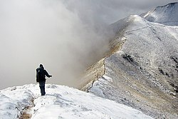
An alpine section of the Kepler Track
|
|
| Length | 60 km (37 mi) |
| Location | Fiordland National Park, Southland, New Zealand |
| Designation | New Zealand Great Walk |
| Trailheads | Lake Te Anau control gates, Rainbow Reach, Brod Bay |
| Use | Hiking, running |
| Elevation | |
| Highest point | Luxmore Saddle 1,400 m (4,600 ft) |
| Lowest point | Lake Manapouri, 178 m (584 ft) |
| Hiking details | |
| Trail difficulty | medium |
| Season | Summer to Autumn |
| Months | Late October to mid April Possible to walk in winter months too, but for experienced hikers only |
| Sights | Ridgetop alpine views, lakes, wetlands, forests, rivers, waterfalls |
| Hazards | Hypothermia, sunburn, high winds |
The Kepler Track is a 60 km (37 mi) circular tramping track which travels through some spectacular scenery of the South Island of New Zealand and is situated near the town of Te Anau. The track passes through many landscapes of the Fiordland National Park such as rocky mountain ridges, tall mossy forests, lake shores, deep gorges, rare wetlands and rivers. Like the mountains it traverses, the track is named after Johannes Kepler. The track is one of the New Zealand Great Walks and is administered by New Zealand Department of Conservation (DOC).
Compared with other tracks in New Zealand, this walking track is constructed to a very high standard. Most streams are bridged, boardwalks cover boggy areas and the very steep sections have steps. It is a moderate walking track that takes three to four days to complete.
The Kepler Track is also home to the Kepler Challenge, an annual running race that traverses the whole 60 kilometres, which the winners complete in less than five hours.
Māori legend has it that Rakaihautu, legendary leader of the Māori migration canoe Uruao, is said to have named the great lakes while exploring the interior of the South Island. During a period of wet weather his party found a large and beautiful lake which they named Te Ana Au, meaning cave of rain, and just south of it another lake which Rakaihautu named Roto Ua, the lake where rain is constant. Today we know Roto Ua as Lake Manapouri. The Kepler is situated between the two lakes.
Richard Henry, Fiordland's first ranger, lived at the southern end of Lake Te Anau for many years and often explored the Kepler area. James McKerrow named the range after the 17th Century German astronomer Johannes Kepler.
Early tracks up onto Mt. Luxmore were cut by Jack Beer to provide summer grazing for his sheep. Many tracks in New Zealand have evolved from Māori trails or pioneer exploration routes. The Kepler track however was established in 1988 and opened in February of that year as a Great Walk as part of the Fiordland National Park Centennial celebrations. Funding came from New Zealand Tourist and Publicity Department. It was designed to ease the strain on the popular Milford and Routeburn Tracks. The track had a considerable contribution from the International Expedition Operation Raleigh during 1986/87, when expeditioners from around the world constructed much of the walkways and the Iris Burn and Mount Luxmore huts.
...
Wikipedia
