Kent Middle School
| Kentfield | |
|---|---|
| census-designated place | |
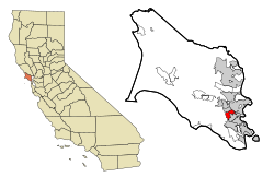
 Location in Marin County and the state of California |
|
| Coordinates: 37°57′08″N 122°33′26″W / 37.95222°N 122.55722°WCoordinates: 37°57′08″N 122°33′26″W / 37.95222°N 122.55722°W | |
| Country |
|
| State |
|
| County | Marin |
| Government | |
| • County Board | District 2 Katie Rice |
| • Senate | Mark Leno (D) |
| • Assembly | Marc Levine (D) |
| • U. S. Congress | Jared Huffman (D) |
| Area | |
| • Total | 3.041 sq mi (7.876 km2) |
| • Land | 3.025 sq mi (7.835 km2) |
| • Water | 0.016 sq mi (0.041 km2) 0.52% |
| Elevation | 115 ft (35 m) |
| Population (2010) | |
| • Total | 6,485 |
| • Density | 2,100/sq mi (820/km2) |
| Time zone | PST (UTC-8) |
| • Summer (DST) | PDT (UTC-7) |
| ZIP codes | 94904, 94914 (PO boxes) |
| Area codes | 415/628 |
| FIPS code | 06-38114 |
| GNIS feature ID | 1658892 |
Kentfield (formerly Ross Landing, Tamalpais, and Kent) is a census-designated place (CDP) in Marin County, California, United States, just north of San Francisco. Kentfield is located on the Northwestern Pacific Railroad 2 miles (3.2 km) southwest of downtown San Rafael, at an elevation of 115 feet (35 m). The population was 6,485 at the 2010 census. The ZIP codes are 94904 for street addresses, and 94914 for PO boxes, and are shared with the neighboring community of Greenbrae.
In 1857, James Ross (1812–1862) bought Rancho Punta de Quentin. Ross, a Scot who had arrived in San Francisco from Australia in 1848 and made his fortune in the wholesale liquor business, set up a trading post called "Ross Landing". Steamers would come up Corte Madera Creek to the landing there. Albert Emmett Kent bought the land from the Ross estate in 1871. Kent built an estate called Tamalpais, later applied to the settlement by the railroad. Albert Emmett Kent's son, William Kent, was a US Congressman, philanthropist and founder of Muir Woods.
The name of the town was changed to Kent in the 1890s, and finally to Kentfield with the opening of the first post office in 1905.
Kentfield is located on the eastern slopes of Mount Tamalpais. It is at 37°57′08″N 122°33′26″W / 37.95222°N 122.55722°W.
...
Wikipedia

