Kennebunkport, Maine
| Kennebunkport, Maine | ||
|---|---|---|
| Town | ||

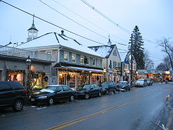
Downtown during the Christmas season, looking towards Dock Square
|
||
|
||
| Location within the state of Maine | ||
| Coordinates: 43°22′51″N 70°27′7″W / 43.38083°N 70.45194°W | ||
| Country | United States | |
| State | Maine | |
| County | York | |
| Incorporated | July 5, 1653 | |
| Government | ||
| • Type | Town Meeting | |
| • Town Manager | Larry Mead | |
| • Board of Selectmen | D. Michael Weston Shelia Matthews-Bull Stuart Barwise Mathew Lanigan Allen Daggett |
|
| Area | ||
| • Total | 49.35 sq mi (127.82 km2) | |
| • Land | 20.52 sq mi (53.15 km2) | |
| • Water | 28.83 sq mi (74.67 km2) | |
| Elevation | 26 ft (8 m) | |
| Population (2010) | ||
| • Total | 3,474 | |
| • Estimate (2012) | 3,506 | |
| • Density | 169.3/sq mi (65.4/km2) | |
| Time zone | Eastern (EST) (UTC-5) | |
| • Summer (DST) | EDT (UTC-4) | |
| ZIP code | 04046 | |
| Area code(s) | 207 | |
| FIPS code | 23-36745 | |
| GNIS feature ID | 0582540 | |
| Website | www |
|
Kennebunkport is a town in York County, Maine, United States. The population was 3,474 people at the 2010 census. It is part of the Portland–South Portland–Biddeford metropolitan statistical area.
The town center, the area in and around Dock Square, is located along the Kennebunk River, approximately 1 mile (1.6 km) from the mouth of the river on the Atlantic Ocean. Historically a shipbuilding and fishing village, for well over a century the town has been a popular summer colony and seaside tourist destination. The Dock Square area has a district of souvenir shops, art galleries, seafood restaurants, and bed and breakfasts. Cape Porpoise, while retaining its identity as a fishing harbor, has a very small village area with several restaurants, a church, grocery store, coffee shop, small library, and art gallery. Kennebunkport has a reputation as a summer haven for the upper class and is one of the wealthiest communities in the state of Maine.
Kennebunkport and neighboring towns Kennebunk and Arundel comprise school district RSU 21.
Kennebunkport was first incorporated in 1663 as Cape Porpus, subject to the government of the Massachusetts Bay Colony (Maine was admitted to the Union in 1820 as part of the Missouri Compromise). Due to Indian depredations, the town was depopulated by 1689, and not resettled by Europeans again until the early 18th century. The town was renamed Arundel, and the town center located inland at Burbank Hill. In 1821 the town was renamed again, this time to Kennebunkport in reflection to its economy becoming one of shipbuilding and trade along the Kennebunk River.
...
Wikipedia


