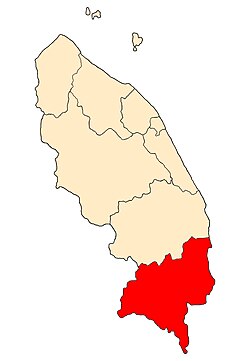
Kemaman District
| Kemaman | ||
|---|---|---|
| Parliamentary constituency District |
||
|
||
 |
||
| Country |
|
|
| State |
|
|
| Seat | Chukai | |
| Government | ||
| • Body | Kemaman Municipal Council | |
| • Yang Di Pertua | Haji Mohd Zulkifli Bin Abu Bakar | |
| Area | ||
| • Total | 2,535.59 km2 (979.00 sq mi) | |
| Population (2016 estimated) | ||
| • Total | 400,587 | |
| • Density | 160/km2 (410/sq mi) | |
| Postcode | 24xxx | |
| National calling code | 09-6xxxxxx | |
| Vehicle registration | T | |
Kemaman (Chinese: 甘马挽) is a district and a parliamentary constituency in Terengganu, Malaysia. Kemaman district is bordered by Dungun district to the north and the state of Pahang to the south and west. It is the southern gateway to the state of Terengganu.
The district administrative seat and the main economic centre of Kemaman is the town of Chukai, near the Terengganu-Pahang state border. Other important towns in this district are Kijal, Kerteh, and Kemasik. The district is administered by the Kemaman Municipal Council (Malay: Majlis Perbandaran Kemaman). With a total area of almost 1000 square miles, it is the third largest district after Hulu Terengganu and Dungun bordering the South China Sea.
Kemaman is divided into twelve mukims:
Based on the 2000 Population and Housing Census, the population of Kemaman totals 137,070 (15.6% of the Terengganu population ). In the 2010 census, there were 167,824 residents in MPK administrative area. Malays were the majority ethnic group with a total of 157,778, while 6937 were Chinese, 743 were Indian, and 264 were from other ethnic groups. Censuses until the 1940s showed that this district as the third highest populated area after Kuala Terengganu and Besut. The population distribution changed after the discovery of oil in the 1970s, placing this district second after Kuala Terengganu.
The geographical features of this district can be divided into three main areas which include coastal area, inland area and the foothill area (located only a few kilometers from the beach). The coastal area is a flat lowland with the majority of the people focus on fishing activities. This area stretches about 38 kilometers from Kuala Kemaman to Kerteh. More than half of Kemaman's population is concentrated in this area. The inland area of the district is a region of highlands with hilly features. This area is rich with tin ore, oil palm plantation and timber. So, the concentration of population here is related to local economic activities. The foothill area is the second highest populated area. The area is located between the coastal and the inland areas. The main occupation of the residents in this area is farming.
According to early history, Kemaman was started to be known since the second century B.C. by the name of 'Kole'. This is based on the map of Malay Land Peninsula which has been drawn by Ptolemy (a Greek astronomer and geographer, born in Egypt in the second century B.C.) noting that there were two ports in the East Coast, Perimula and Kole. Historians agreed that Perimula was the Terengganu River Estuary (present-day Kuala Terengganu) and Kole was Kemaman.
...
Wikipedia

