Kelseyville
| Kelseyville, California | |
|---|---|
| CDP | |

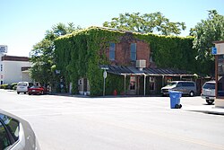
Downtown Kelseyville
|
|
 Location within Lake County and California |
|
| Coordinates: 38°58′41″N 122°50′22″W / 38.97806°N 122.83944°WCoordinates: 38°58′41″N 122°50′22″W / 38.97806°N 122.83944°W | |
| Country |
|
| State |
|
| County | Lake |
| Area | |
| • Total | 2.891 sq mi (7.487 km2) |
| • Land | 2.885 sq mi (7.472 km2) |
| • Water | 0.006 sq mi (0.015 km2) 0.20% |
| Elevation | 1,384 ft (422 m) |
| Population (2010) | |
| • Total | 3,353 |
| • Density | 1,200/sq mi (450/km2) |
| Time zone | Pacific (PST) (UTC-8) |
| • Summer (DST) | PDT (UTC-7) |
| ZIP code | 95451 |
| Area code | 707 |
| FIPS code | 06-38044 |
| GNIS feature ID | 0277532 |
Kelseyville is a census-designated place (CDP) in Lake County, California, United States. Kelseyville is located 6 miles (9.7 km) southeast of Lakeport, at an elevation of 1,384 feet (422 m). The population was 3,353 at the 2010 census, up from 2,928 at the 2000 census.
The community was formerly named Kelsey, Kelsey Creek, Kelsey Town, Peartown, and Uncle Sam. The place was originally called Kelsey Town in honor of Andrew Kelsey, the first European-American settler in Lake County. He was killed in 1850 in an uprising against him by a band of Pomo whom Kelsey had enslaved. This episode ended with the Bloody Island Massacre. The first blacksmith's opened in 1857. The place was called Uncle Sam after Mount Uncle Sam (referred to as Mount Konocti). The Uncle Sam post office opened in 1858 and changed its name to Kelseyville in 1882.
Kelseyville is located in Lake County, California, part of the North Coast American Viticultural Area. Kelseyville includes a growing number of wineries, tasting rooms and breweries. Since February 2016, Kelseyville's Main Street now offers four wine tasting rooms and a beer nan-brewery. The number of wineries in Kelsey is also growing. A notable new entry is Boatique Winery in the Red Hills region. It opened its tasting room in July 2015 and features a large complex and events center that also houses antique boats. The winery also offers panoramic views of the nearby mountains.
According to the United States Census Bureau, the CDP has a total area of 2.9 square miles (7.5 km2), over 99% of it land.
The census district also includes Soda Bay and Riviera Heights, located on the northern slope of Mt. Konocti (Mount Uncle Sam).
...
Wikipedia
