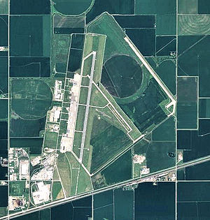
Kearney AAF
| Kearney Air Force Base | |
|---|---|
| Part of Strategic Air Command | |
| Center Township, Buffalo County, near Kearney, Nebraska | |

2006 USGS Orthophoto
|
|
| Coordinates | 40°43′37″N 099°00′24″W / 40.72694°N 99.00667°WCoordinates: 40°43′37″N 099°00′24″W / 40.72694°N 99.00667°W |
| Type | Air Force Base |
| Site history | |
| Built | 1941-1942 |
| In use | 1942-1949 |
Kearney Air Force Base (IATA: EAR, ICAO: KEAR, FAA LID: EAR), was a military airport located four nautical miles (7 km) northeast of the central business district of Kearney, a city in Buffalo County, Nebraska, United States. After its closure, it was redeveloped into Kearney Regional Airport.
In 1940, Kearney had a population of 9,643 people. In the early 1940s, three Nebraska cities, Kearney, Grand Island and Hastings joined together to form the Central Nebraska Defense Council when it was learned that the United States Army Air Forces was considering the site for a military airfield. The group attempted to convince Washington that central Nebraska was a suitable location for defense related activities. Kearney and Grand Island effectively competed with one another as locations for defense airports which would serve as storage for aircraft being produced at Offutt Field and the Glenn L. Martin Bomber Plant near Omaha.
As early as 1941 the City of Kearney voted on a $60,000 bond to finance a new airport. Kearney Regional Airport began as Keens Municipal Airport. The total cost ended up being more than $360,000, with the balance funded by the Works Progress Administration (WPA). Construction began at the site five miles east of Kearney on Highway 30 on 21 October 1941, and was dedicated as Keens Airport on 23 August 1942, with asphalt runways and a single hangar
...
Wikipedia


