Kawthaung
|
Kawthaung ကော့သောင်းမြို့ |
|
|---|---|
| Town | |

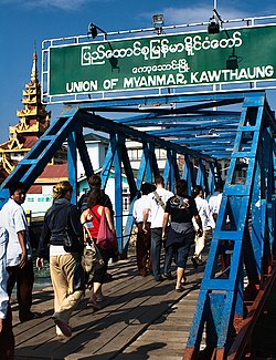
Border crossing at Kawthaung
|
|
| Location in Burma | |
| Coordinates: 9°59′N 98°33′E / 9.983°N 98.550°ECoordinates: 9°59′N 98°33′E / 9.983°N 98.550°E | |
| Country |
|
| Region | Tanintharyi Region |
| District | Kawthaung District |
| Township | Kawthaung Township |
| Time zone | MST (UTC+6.30) |
Kawthaung (Burmese: ကော့သောင်းမြို့; MLCTS: kau. saung: mrui., IPA: [kɔ̰θáʊɴ mjo̰]; Thai: เกาะสอง; rtgs: Ko Song, pronounced [kɔ̀ʔ sɔ̌ːŋ]; Malay: Pulodua, ڤولودوا) is in the southernmost part of Myanmar, located in Tanintharyi Region. During British rule in Burma between 1824 and 1948, it was known as Victoria Point.
Rakhine and Tanintharyi were transferred to British rule after the first Anglo-Burmese War of 1823-1826.
In 1859, a local group of Chinese and Thais settled at Maliwan (Thai Language) to the north of Kawthaung, a place with numerous lakes and flowering trees. In 1865, an Arab-Malay group led by Nayuda Ahmed, traveling and collecting sea products around Mergui Archipelago started a base and village at the bay of Victoria Point.
In 1872 the third mayor of Mergui District, Sir Ashly Din (1870–1875) assigned the first police officer to be stationed at Maliwan, a village 24 miles north of current Victoria Point. In 1891, the local government offices were moved from Maliwan to Kawthaung because Maliwan is located on the bank of a small shallow river, Maliwan Creek, unsuitable for large ships to enter and waiting tide water.
...
Wikipedia

