Kattakkada
|
Kattakada കാട്ടാക്കട |
|
|---|---|
| Town | |

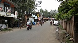
Kattakkada Road at Ottasekhara Mangalam
|
|
| Coordinates: 8°30′15″N 77°4′49″E / 8.50417°N 77.08028°ECoordinates: 8°30′15″N 77°4′49″E / 8.50417°N 77.08028°E | |
| Country |
|
| State | Kerala |
| District | Thiruvananthapuram |
| Population (2001) | |
| • Total | 37,463 |
| Languages | |
| • Official | Malayalam, English |
| Time zone | IST (UTC+5:30) |
| PIN | 695572 |
| Telephone code | 0471 |
| Vehicle registration |
KL- 01 , KL-19 , KL-20 KL-21 |
KL-
Kattakada is a town in the eastern part of Thiruvananthapuram, the capital city of the Indian state of Kerala.
Kattakada is the entry point to the mountain ranges (Western Ghats) and the nerve centre of the eastern parts of the district. Also, it is a growing educational centre in the Trivandrum district, which fast emerges as the educational hub of the district. The present day Kattakada town lies in two village panchayts; Kattakada and Poovachal. Many important institutions like the Primary Health Centre, the public market, the post office, Christian College, etc. are situated in Poovachal Panchayat. The virtual population present in the semi-urban areas of the town is calculated to be between 15,000 and 20,000, while the combined population of both these panchayats is 70,000.
Kattakada Taluk (Tehsil) was declared in the Legislative Assembly in March 2013. The new Taluk was inaugurated on 11 February 2014. Kattakada is a constituency in the Legislative Assembly since 2011.Presently Adv.I.B.Satheesh represend the constituency after former Speaker of Kerala Legislative Assembly, N.Saktan of Congress faced a surprise defeat from him in the 2016 assembly election. A considerable portion of the town which forms part of Poovachal Panchayat, is included in the neighbouring Aruvikara Assembly constituency.
Kattakada is in the eastern part of Thiruvanathapram (Trivandrum) District. It is situated about 18 km east of Trivandrum, the capital of Kerala. To its north is situated Nedumangad (18 km) and to its south, Neyyattinkara (14 km). It is a commercial centre and the second biggest market of hill products in the district, after Nedumangad. Neyyar Dam, a tourist spot and the core of Agasthyavanam Wildlife Sanctuary, is only 10 km away from Kattakada, towards the east. Thus, Kattakada is situated at the centre of four places: Trivandrum to the west, Neyyattinkara to the south, Neyyar Dam to the east and Nedumangad to the north.
The nearest railway stations are Trivandrum Central(18 km), Balaramapuram (10 km) and Neyyattinkara (13 km).
The nearest airport is Thiruvananthapuram International Airport.
Kattakada was a sleepy village till the beginning of the nineteenth century. Few small temples owned by private families were the only institutions in the village. A village market began to develop when merchants and vendors from present day Kanyakumari District and Tamil Nadu began to assemble under a banyan tree, situated in front of the Bhadra Kali Temple. Thus, the place began to be called ‘Kattalkada’, meaning the market of wild banyan tree. This name gradually got itself abbridged and became “Kattakada”. Red chilli, onion and other spices formed items of merchandise in the initial stage. It may be interesting to know that these items were not native to our land; in fact, they were brought to India by the Europeans.
...
Wikipedia
