Karur district
|
Karur District கரூர் மாவட்டம் Karuvur Mavattam |
|
|---|---|
| District | |

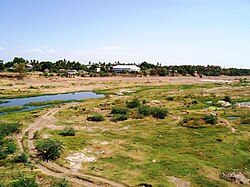
Part of the Amaravathy river basin near Karur
|
|
 Location in Tamil Nadu, India |
|
| Coordinates: 10°57′28.8″N 78°4′48″E / 10.958000°N 78.08000°ECoordinates: 10°57′28.8″N 78°4′48″E / 10.958000°N 78.08000°E | |
| Country |
|
| State | Tamil Nadu |
| Municipality | karur Kulitalai |
| Town Panchayats | 10 |
| Headquarters | Karur |
| Taluka6 | Aravakurichi, Karur, Kadavur, Krishnarayapuram, Kulithalai, Manmangalam |
| Government | |
| • Collector | Mr.G.Govindaraj IAS |
| • SP | Mr.Rajasekaran IPS |
| Area | |
| • Total | 2,856 km2 (1,103 sq mi) |
| Population (2011) | |
| • Total | 1,076,588 |
| • Density | 373/km2 (970/sq mi) |
| Languages | |
| • Official | Tamil |
| Time zone | IST (UTC+5:30) |
| PIN | 639xxx, |
| Telephone code | +91(0)4324, +91(0)4323, +91(0)4320 |
| Vehicle registration | TN 47 |
| Largest city | Karur |
| Sex ratio | 1015 ♂/♀ |
| Literacy | 81.74% |
| Lok Sabha constituency | 1 - Karur |
| Vidhan Sabha constituency | 4 |
| Climate | Max 38c - Min 17c (Köppen) |
| Website | karur |
Karur District is a district located very centrally along the Kaveri and Amaravathi rivers in the Indian state of Tamil Nadu. The main town in Karur District is the city of Karur, which is also the district headquarters. The district had a population of 1,064,493 with a sex-ratio of 1,015 females for every 1,000 males.
Karur is one of the oldest towns in Tamil Nadu and has played a very significant role in the history and culture of the Tamils. Its history dates back over 2000 years, and has been a flourishing trading center even in the early Sangam days. In the ancient and medieval times, the area was ruled by the Cheras, Gangas and Cholas. Karur was the capital of Cheras.The Pasupatheesvarar Temple sung by Thirugnana Sambhandar, in Karur was built by the Chola kings in the 7th century. Later the Nayakars followed by Tipu Sultan also ruled Karur. The British added Karur to their possessions after destroying the Karur Fort during their war against Tipu Sultan in 1783. There is a memorial at Rayanur near Karur for the warriors who lost their lives in the fight against the British in the Anglo-Mysore Wars. Thereafter Karur became part of British India and was first part of Coimbatore District and later Tiruchirappalli District. Karur district was formed on 30th September 1995 by trifurcating Tiruchirappalli district.
With headquarters at Karur, it is the centrally located district of Tamil Nadu. It is bounded by Namakkal district in the north, Dindigul district in the south, Tiruchirapalli district on the east and Erode & Tiruppur districts on the west. Karur is located at 10°57'° N 78°4'° E has an average elevation of 122 metres (400 feet). It is about 371 km (231 mi) south west of Chennai (Madras), the state capital of Tamil Nadu.
The highest temperature is obtained in early May to early June usually about 34 °C (93.2 °F), though it usually exceeds 38 °C (100.4 °F) for a few days most years. Average daily temperature in Karur during January is around 23 °C (73.4 °F), though the temperature rarely falls below 17 °C (62.6 °F). The average annual rainfall is about 775 mm (30.5 in). It gets most of its seasonal rainfall from the north-east monsoon winds, from late September to mid November.
According to 2011 census, Karur district had a population of 1,076,588 with a sex-ratio of 1,015 females for every 1,000 males, much above the national average of 929. A total of 102,731 were under the age of six, constituting 52,969 males and 49,762 females. Scheduled Castes and Scheduled Tribes accounted for 20.8% and .05% of the population respectively. The average literacy of the district was 68.3%, compared to the national average of 72.99%. The district had a total of 287,095 households. There were a total of 543,298 workers, comprising 83,800 cultivators, 182,639 main agricultural laborers, 10,162 in house hold industries, 231,906 other workers, 34,791 marginal workers, 2,072 marginal cultivators, 18,198 marginal agricultural laborers, 1,178 marginal workers in household industries and 13,343 other marginal workers.
...
Wikipedia
