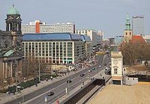
Karl-Liebknecht-Straße
|
|
|
|---|---|

Karl-Liebknecht-Straße with Berlin Cathedral and St. Mary's Church
|
|

Southern section between Spree and Alexanderplatz
|
|
| Length | 1.3 km (0.8 mi) |
| Location | Mitte, Berlin |
| Southwest end | Schloßplatz/Liebknecht Bridge |
| Northeast end | Prenzlauer Allee |
| Construction | |
| Inauguration | 1889/1969 |
Karl-Liebknecht-Straße is a major street in the central Mitte district of the German capital Berlin. It is named after Karl Liebknecht (1871–1919), one of the founders of the Communist Party of Germany. The street connects the Unter den Linden boulevard with the Prenzlauer Allee arterial road leading to the northern city limits. Although part of the street dates back to medieval times, most of the buildings at its side were built in the 1960s, when East Berlin's centre was redesigned as the capital of East Germany.
The origins of the street lie in the quarter that arose about 1270 around St. Mary's Church, located north of Alt-Berlin's initial settlement. The "New Market" (Neuer Markt) square beneath the church was first mentioned in a 1292 deed; there were three alleys that went southwest from it down to the Spree river. They had had different names over the centuries and were ultimately known as Papenstraße (“Bishops' Street”, named for the Berlin residence of the Havelberg bishops), Brauhausstraße (“Brewery Street”) and Kleine Burgstraße (“Castle Street”, named for the City Palace on the other side of the river).
Since the 17th century, a wooden pedestrian bridge, known as Castle Bridge, later called Cavalier Bridge or Sechserbrücke (“Sixpence Bridge”), would lead from Kleine Burgstraße across the water to the Berlin City Palace on Spree Island and the eastern terminus of Unter den Linden. However, traffic from the west crossing Schlossbrücke still had to turn right in front of the Palace and continue its way to Alt-Berlin via the parallel Rathaus Bridge.
In the 1880s, plans for a new traffic routing were developed when it was decided to build a northeastern extension of the Unter den Linden boulevard through the Palace's Lustgarten. In 1884 the German Emperor William I gave his consent to replace the pedestrian bridge with a much larger, richly ornamented stone construction. Beyond the river, after lengthy negotiations with numerous property owners, the three historic alleys were combined to a broad street, built according to plans designed by August Orth, to complete the interconnection from Unter den Linden to the New Market square.
...
Wikipedia
