Kapiti Island

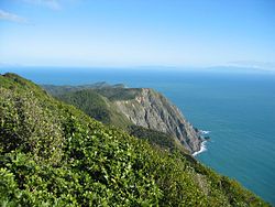
Looking south from Kāpiti Island.
|
|
| Geography | |
|---|---|
| Location | Tasman Sea |
| Coordinates | 40°52′S 174°54′E / 40.867°S 174.900°E |
| Area | 19.65 km2 (7.59 sq mi) |
| Length | 8 km (5 mi) |
| Width | 2 km (1.2 mi) |
| Highest elevation | 521 m (1,709 ft) |
| Highest point | Tuteremoana |
| Administration | |
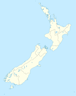
Kāpiti Island is a small but conspicuous island about 5 km (3 mi) off the west coast of the lower North Island of New Zealand. It is 8 kilometres (5.0 mi) long, running southwest/northeast, and roughly 2 kilometres (1.2 mi) wide, being more or less rectangular in shape, and has an area of 19.65 km2 (7.59 sq mi).
The island is separated from the North Island by the Rauoterangi channel. The highest point on the island is Tuteremoana, 521 m (1,709 ft). The seaward (west) side of the island is particularly rocky and has high cliffs, some hundreds of metres high, that drop straight into the sea. The cliffs are subject to very strong prevailing westerly winds and the scrubby vegetation that grows there is low and stunted by the harsh environmental conditions. A cross-section of the island would show almost a right-angled triangle, revealing its origins from lying on a fault line (part of the same ridge as the Tararua Range).
The island's vegetation is dominated by scrub and forest of kohekohe, tawa, and kanuka. Most of the forest is regenerating after years of burn-offs and farming, but some areas of original bush with 30 m (98 ft) trees remain.
Its name has been used since 1989 by the Kāpiti Coast District Council, which includes towns such as Paekakariki, Raumati, Paraparaumu and Waikanae.
In the 18th and 19th centuries Māori settled on the island. Te Rauparaha formed a base here, and his Ngāti Toa tribe regularly sailed in canoes on raiding journeys up to the Whanganui River and down to Marlborough. In the Battle of Wairo (1824) the Ngāti Toa destroyed a force of 2,000 mainland warriors who had landed at the northern end of Kāpiti in an attempt to capture the island.
...
Wikipedia

