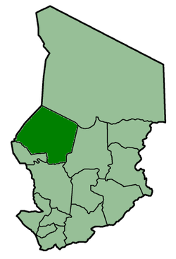
Kanem Prefecture
| Kanem Prefecture Préfecture du Kanem |
|||||
| Prefecture of Chad | |||||
|
|||||
| Capital |
Mao 14°07′N 15°18′E / 14.117°N 15.300°ECoordinates: 14°07′N 15°18′E / 14.117°N 15.300°E |
||||
| Government | Prefecture | ||||
| Historical era | Cold War | ||||
| • | Established | 13 February 1960 | |||
| • | Separation of Lac Prefecture | 29 October 1962 | |||
| • | Disestablished | 1 September 1999 | |||
| Area | |||||
| • | 1960 | 150,000 km2(57,915 sq mi) | |||
| • | 1993 | 114,520 km2(44,216 sq mi) | |||
| Population | |||||
| • | 1960 | 215,133 | |||
| Density | 1.4 /km2 (3.7 /sq mi) | ||||
| • | 1993 | 279,927 | |||
| Density | 2.4 /km2 (6.3 /sq mi) | ||||
| Political subdivisions |
Sub-prefectures (1993)
|
||||
| Area and population source: | |||||
This article refers to one of the former prefectures of Chad. From 2002 the country was divided into 18 regions.
Kanem was one of the 14 prefectures of Chad. Located in the west of the country, Kanem covered an area of 114,520 square kilometers and had a population of 279,927 in 1993. Its capital was Mao.
Batha · Biltine · Borkou-Ennedi-Tibesti · Chari-Baguirmi · Guéra · Kanem · Lac · Logone Occidental · Logone Oriental · Mayo-Kébbi · Moyen-Chari · Ouaddaï · Salamat · Tandjilé ·
See also : Regions of Chad - Departments of Chad
...
Wikipedia


