Kanem (region)
|
Kanem كانم |
|
|---|---|
| Region | |

Oasis in Mao, capital of Kanem Region
|
|
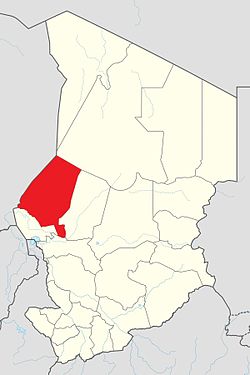
 Map of Chad showing Kanem. |
|
| Country | Chad |
| Departments | 3 |
| Sub-prefectures | 10 |
| Regional capital | Mao |
| Government | |
| • Governor | N'Gamaï Djari (2008) |
| Population (2009) | |
| • Total | 354,603 |
Coordinates: 14°07′10″N 15°18′48″E / 14.1194°N 15.3133°E
Kanem (Arabic: كانم) is one of the 23 regions of Chad. It was created in 2002 from the former Prefecture of Kanem. It is named after the famous Kanem Empire, which was centered in this vicinity. The region's capital is Mao. In 2008, a portion of the Kanem region (the Bahr el Gazel Department) was split off to become the new Bahr el Gazel Region.
Per the census of 2009, the total population in the region was 354,603, 51.40 percent females. The total number of households was 78,145: it was 70,779 in rural areas and 7,366 in urban areas. The number of nomads in the region was 10,056, 2.60 percent of the total population.
Kanem is traversed by the northeasterly line of equal latitude and longitude. Chad has a general elevation of 240 m (790 ft) in Lake Chad Depression towards Guera massif located at an elevation of 1,800 m (5,900 ft) and eastwards towards the mountaineous Saharan region of 3,350 m (10,990 ft). The only rivers in the country of importance are Chari and Logone, flowing into Lake Chad. The region receives an annual rainfall of 744 mm (29.3 in) and has vegetational zones. The region is the principal agricultural segment in the whole country, producing cotton and groundnut, the two main cash crops of the country. There are a variety of local crops like rice are also grown in the region.
...
Wikipedia
