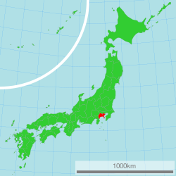
Kanagawa, Japan
|
Kanagawa Prefecture 神奈川県 |
|||
|---|---|---|---|
| Prefecture | |||
| Japanese transcription(s) | |||
| • Japanese | 神奈川県 | ||
| • Rōmaji | Kanagawa-ken | ||
|
|||
 |
|||
| Coordinates: 35°26′51.03″N 139°38′32.44″E / 35.4475083°N 139.6423444°ECoordinates: 35°26′51.03″N 139°38′32.44″E / 35.4475083°N 139.6423444°E | |||
| Country | Japan | ||
| Region | Kantō | ||
| Island | Honshu | ||
| Capital | Yokohama | ||
| Government | |||
| • Governor | Yūji Kuroiwa (since April 2011) | ||
| Area | |||
| • Total | 2,416.04 km2 (932.84 sq mi) | ||
| Area rank | 43rd | ||
| Population (September 1, 2014) | |||
| • Total | 9,098,984 | ||
| • Rank | 2nd | ||
| • Density | 3,770/km2 (9,800/sq mi) | ||
| ISO 3166 code | JP-14 | ||
| Districts | 6 | ||
| Municipalities | 33 | ||
| Flower | Golden-rayed lily (Lilium auratum) | ||
| Tree | Ginkgo (Ginkgo biloba) | ||
| Bird | Common gull (Larus canus) | ||
| Website | www |
||
Kanagawa Prefecture (神奈川県 Kanagawa-ken?) is a prefecture located in southern Kantō region of Japan. The capital of the prefecture is Yokohama. Kanagawa is part of the Greater Tokyo Area. Kanagawa Prefecture is home to Kamakura and Hakone, two highly popular side trip destinations from Tokyo.
The prefecture has some archaeological sites going back to the Jōmon period (around 400 BCE). About 3,000 years ago, Mount Hakone produced a volcanic explosion which resulted in Lake Ashi on the western area of the prefecture.
It is believed that the Yamato dynasty ruled this area from the 5th century onwards. In the ancient era, its plains were very sparsely inhabited.
In medieval Japan, Kanagawa was part of the provinces of Sagami and Musashi.Kamakura in central Sagami was the capital of Japan during the Kamakura period (1185–1333).
During the Edo period, the western part of Sagami Province was governed by the daimyō of Odawara Castle, while the eastern part was directly governed by the Tokugawa shogunate in Edo (Tokyo).
...
Wikipedia


