Kamo River
| Kamo River | |
|---|---|

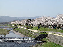
Cherry blossoms along the Kamo River
|
|
| Native name | 鴨川 |
| Country | Japan |
| Basin features | |
| Main source | 896 m (2,940 ft) |
| River mouth | Yodo River |
| River system | Yodo River |
| Basin size | 210 km2 (81 sq mi) |
| Physical characteristics | |
| Length | 31 km (19 mi) |
The Kamo River (鴨川 Kamo-gawa?, duck river – see onomastics) is located in Kyoto Prefecture, Japan. The riverbanks are popular walking spots for residents and tourists. In summer, restaurants open balconies looking out to the river. There are pathways running alongside the river on which one can walk along the river, and some stepping stones that cross the river. The water level of the river is usually relatively low; less than one meter in most places. During the rainy season, however, the pathways sometimes flood in their lower stretches.
The Kamo River has its source in the mountains in the area of Mount Sajikigatake, around the boundary of Kumogahata village and Keihoku village in the northern ward of Kyoto. Flowing into the Kyoto Basin from the city area called Kamigamo in the same northern ward of the city, from there it bends south-east and, around the spot known as Demachi in the Kamigyō (or "Upper Kyoto" ward), joins with the Takano River which flows down from the northeastern direction, and there changes direction to due south through Kyoto's Nakagyō ("Central") ward. In the vicinity of the Shijō Bridge at Shijō Street in the center of downtown Kyoto, the Shirakawa River joins with it. At its southern part, the Horikawa River and West Takase River join with it, and at Shimomukōjima-cho in the Shimotoba part of Fushimi Ward of Kyoto City, it joins with the Katsura River, to become a tributary of the Yodo River.
...
Wikipedia
