Kameyama, Mie
|
Kameyama 亀山市 |
|||
|---|---|---|---|
| City | |||

Kameyama City Hall in Honmaru area
|
|||
|
|||
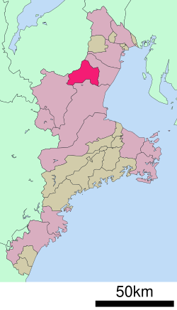
 Location of Kameyama in Mie Prefecture |
|||
| Coordinates: 34°51′21″N 136°27′6″E / 34.85583°N 136.45167°ECoordinates: 34°51′21″N 136°27′6″E / 34.85583°N 136.45167°E | |||
| Country | Japan | ||
| Region | Kansai | ||
| Prefecture | Mie Prefecture | ||
| Government | |||
| • -Mayor | Yoshiyuki Sakurai (since February 2009) | ||
| Area | |||
| • Total | 190.91 km2 (73.71 sq mi) | ||
| Population (November 2012) | |||
| • Total | 50,230 | ||
| • Density | 263/km2 (680/sq mi) | ||
| Time zone | Japan Standard Time (UTC+9) | ||
| - Tree | Cryptomeria | ||
| - Flower | Japanese iris | ||
| Phone number | 0595-82-1111 | ||
| Address | 577 Honmaru-cho, Kameyama-shi, Mie-ken 519-0195 | ||
| Website | www |
||
Kameyama (亀山市 Kameyama-shi?) is a city located in northern Mie Prefecture, Japan.
As of November 2012, the city has an estimated population of 50,230 and a population density of 263 persons per km². The total area is 190.91 km2 (73.71 square miles).
Kameyama developed as the castle town of Kameyama Castle, which belonged to the Ise-Kameyama Domain under the Tokugawa shogunate. In the early 17th century, the castle town was Kameyama-juku, the forty-sixth post station of Tōkaidō. Seki-juku and Sakashita-juku on the Tōkaidō, also fall within its borders. During the establishment of municipalities in the early Meiji period, Kamayama-juku was organized into the town of Kameyama within Suzuka District. It was elevated to city status on October 1, 1954.
On January 11, 2005, the town of Seki (also from Suzuka District) was merged into Kameyama.
Candles are a traditional product of the city. Sharp Corporation has been operating one of the world's largest LCD factories in the city since January 8, 2004.
...
Wikipedia


