Kamchatka Peninsula
| полуо́стров Камча́тка | |
|---|---|

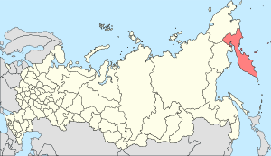
Kamchatka Peninsula in the far east of Russia. The pink area is the Kamchatka Krai which includes some of the mainland to the north.
|
|
| Geography | |
| Location | Far East |
| Coordinates | 57°N 160°E / 57°N 160°ECoordinates: 57°N 160°E / 57°N 160°E |
| Adjacent bodies of water | |
| Area | 270,000 km2 (100,000 sq mi) |
| Highest elevation | 4,750 m (15,580 ft) |
| Highest point | Klyuchevskaya Sopka |
| Administration | |
| Federal subject | Kamchatka Krai |
| Capital and largest city | Petropavlovsk-Kamchatsky |
| Demographics | |
| Population | 322,079 |
| Petropavlovsk-Kamchatsky | ||||||||||||||||||||||||||||||||||||||||||||||||||||||||||||
|---|---|---|---|---|---|---|---|---|---|---|---|---|---|---|---|---|---|---|---|---|---|---|---|---|---|---|---|---|---|---|---|---|---|---|---|---|---|---|---|---|---|---|---|---|---|---|---|---|---|---|---|---|---|---|---|---|---|---|---|---|
| Climate chart () | ||||||||||||||||||||||||||||||||||||||||||||||||||||||||||||
|
||||||||||||||||||||||||||||||||||||||||||||||||||||||||||||
|
||||||||||||||||||||||||||||||||||||||||||||||||||||||||||||
| J | F | M | A | M | J | J | A | S | O | N | D |
|
118
−5
−10
|
80
−5
−9
|
84
−2
−7
|
90
2
−3
|
64
7
1
|
53
12
6
|
62
15
9
|
91
16
10
|
111
13
7
|
174
8
3
|
130
1
−3
|
109
−4
−8
|
| Average max. and min. temperatures in °C | |||||||||||
| Precipitation totals in mm | |||||||||||
| Source: | |||||||||||
| Imperial conversion | |||||||||||
|---|---|---|---|---|---|---|---|---|---|---|---|
| J | F | M | A | M | J | J | A | S | O | N | D |
|
4.6
23
14
|
3.1
24
15
|
3.3
29
19
|
3.5
36
27
|
2.5
44
34
|
2.1
53
42
|
2.4
59
49
|
3.6
61
50
|
4.4
56
45
|
6.9
46
37
|
5.1
34
26
|
4.3
26
18
|
| Average max. and min. temperatures in °F | |||||||||||
| Precipitation totals in inches | |||||||||||
| Klyuchi | |||||||||||||
|---|---|---|---|---|---|---|---|---|---|---|---|---|---|
| Climate chart () | |||||||||||||
|
