Kalamazoo-Portage, MI MSA
|
Metropolitan Kalamazoo Kalamazoo–Portage MSA Kalamazoo–Battle Creek–Portage CSA |
|
|---|---|
| CSA | |

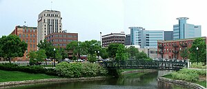
Downtown skyline
|
|
| Coordinates: 42°10′21″N 85°21′09″W / 42.1724°N 85.3524°W | |
| Country |
|
| State |
|
| Largest city |
|
| Counties |
List
|
| Population (2015) | |
| • MSA | 335,340 |
| • CSA | 530,672 |
| Time zone | EST (UTC-5) |
| • Summer (DST) | EDT (UTC-4) |
The Kalamazoo-Portage Metropolitan Area comprises a region surrounding Kalamazoo. 2015 estimates placed it as the 151st largest among similarly designated areas in the United States. 2015 estimates place the combined statistical area 85th among similarly designated areas.
The Kalamazoo-Portage Metropolitan Area is a United States metropolitan area defined by the federal Office of Management and Budget (OMB) consisting of two counties, Kalamazoo and Van Buren, in western Michigan, anchored by the cities of Kalamazoo and Portage. As of the 2010 census, the Metropolitan Statistical Area (MSA) had a population of 326,589.
The Kalamazoo – Battle Creek – Portage Combined Statistical Area ties for 3rd largest CSA in the U.S. state of Michigan. As of the 2010 census, the CSA had a population of 524,030. The CSA combines the two population centers of Kalamazoo and Battle Creek. It includes the two counties of the Kalamazoo-Portage Metropolitan Statistical Area plus one metropolitan area, Battle Creek in Calhoun County and one micropolitan area, Sturgis in St. Joseph County.
...
Wikipedia
