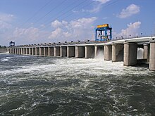
Kakhovka Hydroelectric Power Plant
| Kakhovka Dam | |
|---|---|

The dam's spillway
|
|
|
Location of Kakhovka Dam in Ukraine
|
|
| Official name | Kakhovska HPS |
| Location | Kakhovka, Ukraine |
| Coordinates | 46°46′34.12″N 33°22′17.44″E / 46.7761444°N 33.3715111°ECoordinates: 46°46′34.12″N 33°22′17.44″E / 46.7761444°N 33.3715111°E |
| Purpose | Power, irrigation, navigation |
| Status | Operational |
| Construction began | September 1950 |
| Opening date | 1956 |
| Owner(s) | Energy Company of Ukraine |
| Dam and spillways | |
| Type of dam | Earth-fill embankment with gravity sections |
| Impounds | Dnieper River |
| Height | 30 m (98 ft) |
| Length | 3,273 m (10,738 ft) |
| Reservoir | |
| Creates | Kakhovka Reservoir |
| Total capacity | 18,180×106 m3 (14,738,766 acre·ft) |
| Surface area | 2,155 km2 (832 sq mi) |
| Power station | |
| Operator(s) | Ukrhydroenerho |
| Commission date | 1955-1956 |
| Turbines | 3 x 58.5, 3 x 60.5 MW propeller |
| Installed capacity | 357 MW |
| Annual generation | 1.4 TWh |
The Kakhovka Hydroelectric Station is a run-of-river power plant on the Dnieper River in Kakhovka, Ukraine. Kakhovka is a port city located on the reservoir's southern bank. The primary purpose of the dam is hydroelectric power generation, irrigation and navigation. It is the 6th and the last dam in the Dnieper cascade.
The staff of Kakhovka Hydroelectric Power Plant was 241 person in 16.10.2015. The director is Yaroslav Kobelya from September 2012.
The dam has an associated lock and a power station with an installed capacity of 357 MW. Water from Kakhovka Reservoir is sent via the North Crimean Canal and Dnieper–Kryvyi Rih Canal to irrigate large areas of southern Ukraine and northern Crimea. Construction on the dam began in September 1950 and the last generator was commissioned in October 1956. It is operated by Ukrhydroenerho.
...
Wikipedia

