Kaiserstuhl (Baden)
| Kaiserstuhl | |
|---|---|

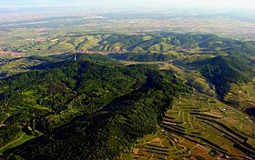
The Kaiserstuhl hills including the Totenkopf with its transmission tower, the village of Oberbergen beyond it and the Rhine River in the background (aerial view looking north-northwest)
|
|
| Highest point | |
| Peak | Totenkopf |
| Elevation | 556.6 m above NHN |
| Geography | |
| State | Counties of Emmendingen and Breisgau-Hochschwarzwald; Baden-Württemberg, |
| Range coordinates | 48°04′51″N 7°40′14″E / 48.08083°N 7.67056°ECoordinates: 48°04′51″N 7°40′14″E / 48.08083°N 7.67056°E |
| Parent range | Southern Upper Rhine Plain |
| Geology | |
| Orogeny | Volcanic range of the German Central Uplands |
The Kaiserstuhl (![]() German pronunciation ) (literally: "Emperor’s Chair") is a range of hills in the state of Baden-Württemberg in southwest Germany with a maximum height of 556.6 metres (1,826 ft). It is of volcanic origin and located in the southwest of the state in the counties of Emmendingen and Breisgau-Hochschwarzwald. In terms of natural regions it is considered to be a part of the Upper Rhine Plain.
German pronunciation ) (literally: "Emperor’s Chair") is a range of hills in the state of Baden-Württemberg in southwest Germany with a maximum height of 556.6 metres (1,826 ft). It is of volcanic origin and located in the southwest of the state in the counties of Emmendingen and Breisgau-Hochschwarzwald. In terms of natural regions it is considered to be a part of the Upper Rhine Plain.
The name "Kaiserstuhl" is believed to refer to King Otto III, who held court near Sasbach on 22 December 994. From then on, the whole hill range was called the Königsstuhl – the King’s Chair. In May 996, Otto III was crowned Emperor and the King’s Chair eventually became the Emperor’s Chair – "Kaiserstuhl". Reliable sources mention the name Kaiserstuhl only as early as 1304 and historians thus suppose that the term Kaiserstuhl was not coined until the 13th century.
The Kaiserstuhl is situated in South Baden, mainly in Breisgau-Hochschwarzwald county or district. However, the smaller northern part belongs to Emmendingen. Within the Upper Rhine Plain it is situated about 16 km northwest of the city of Freiburg, right next to the eastern bank of the Rhine and a short distance west of the Dreisam. It reaches up to 377 metres above the level of the Rhine downstream (179.5 m a.s.l.) from the weir close to Burkheim.
...
Wikipedia

