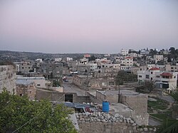
Kafr Jammal
| Kufr Jammal | |
|---|---|
| Other transcription(s) | |
| • Arabic | كفر جمّال |

Kufr Jammal
|
|
| Location of Kufr Jammal within the Palestinian territories | |
| Coordinates: 32°13′31″N 35°02′39″E / 32.22528°N 35.04417°ECoordinates: 32°13′31″N 35°02′39″E / 32.22528°N 35.04417°E | |
| Palestine grid | 154/181 |
| Governorate | Tulkarm |
| Government | |
| • Type | Village council |
| Population (2006) | |
| • Jurisdiction | 2,550 |
| Name meaning | The village of camel-drivers |
Kafr Jammal (Arabic: كفر جمّال), is a Palestinian town in the Tulkarm Governorate in the western edge of the West Bank. It is located about halfway between Qalqilyah and Tulkarm, and has a population of around 3,000. The village is mainly agricultural, and mostly raises olive and citrus crops. Kafr Jammal is at an altitude of 257 meters, and is bordered by Falamya in the west, Kafr Zibad in the east, Jayyous in the south, and Kafr Sur to the north.
Ceramics from the Byzantine era have been found here.
Kafr Jammal was incorporated into the Ottoman Empire in 1517 with all of Palestine, and in 1596 it appeared under that name in the tax registers as being in the Nahiya of Bani Sa'b of the Liwa of Nablus. It had a population of 17 households and 13 bachelors, all Muslims. The villagers paid a fixed tax rate of 33,3% on various agricultural products, such as wheat, barley, summer crops, olive trees, goats and/or beehives, in addition to "occasional revenues" and a press for olive oil or grape syrup; a total of 11,074 akçe.
In 1838, Kefr Jemmal was noted as a village in the Beni Sa'ab area, west of Nablus. In 1882, the Palestine Exploration Fund's Survey of Western Palestine described Kefr Jemmal as "a small stone village on a knoll, with cisterns."
...
Wikipedia

