Kadesh (Syria)

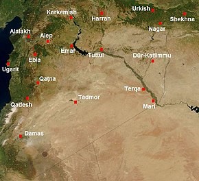
Map of Syria in the second millennium BC, showing the location of Kadesh (Qadesh)
|
|
| Location | Syria |
|---|---|
| Region | Homs Governorate |
| Coordinates | 34°33′28″N 36°31′11″E / 34.55781°N 36.5196°E |
Kadesh (also Qadesh) was an ancient city of the Levant, located on or near the headwaters or a ford of the Orontes River. It was of some importance during the Late Bronze Age, and is mentioned in the Amarna letters. It was the site of the Battle of Kadesh between the Hittite and Egyptian empires in the 13th century BC.
The name is from the West Semitic (Canaanite) root Q-D-Š "holy". It is rendered Qdšw in Egyptian and Kadeš in Hittite. Akkadian spelling variants include Kinza, Kidša, Gizza.
Kadesh is identified with the ruins at Tell Nebi Mend, about 24 kilometers (15 mi) southwest of Homs near al-Qusayr and adjacent to the modern-day Syrian village of Tell al-Nabi Mando. The text of the Kadesh inscriptions locates Kadesh as being near Tunip in the land of the Amurru, itself assumed to have been near the Orontes River (perhaps at Tell Salhab).
Some scholars also identify Kadesh with the city of Kadytis mentioned by Herodotus (2.159, an alternative identification for Kadytis being Gaza.
The site of Tell Nebi Mend was first occupied during the Chalcolithic period. The city first entered historical records when it was mentioned in the archive of Mari in the 18th century BC as the headquarter of king Ishi-Adad of Qatna who took up residence there to oversee the quelling of a rebellion in the south of the city.
...
Wikipedia

