Kōnosu, Saitama
|
Kōnosu 鴻巣市 |
||
|---|---|---|
| City | ||

Kōnosu City Hall
|
||
|
||
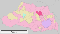
 Location of Kōnosu in Saitama Prefecture |
||
| Location of Kōnosu in Saitama Prefecture | ||
| Coordinates: 36°03′57.2″N 139°31′19.9″E / 36.065889°N 139.522194°ECoordinates: 36°03′57.2″N 139°31′19.9″E / 36.065889°N 139.522194°E | ||
| Country | Japan | |
| Region | Kantō | |
| Prefecture | Saitama Prefecture | |
| Area | ||
| • Total | 67.44 km2 (26.04 sq mi) | |
| Population (February 2016) | ||
| • Total | 118,087 | |
| • Density | 1,750/km2 (4,500/sq mi) | |
| Time zone | Japan Standard Time (UTC+9) | |
| – Tree | Zelkova serrata | |
| – Flower | Pansy | |
| Phone number | 048-541-1321 | |
| Address | 1-1-1 Chuo, Kōnosu-shi, Saitama-ken 365-8601 | |
| Website | Official website | |
Kōnosu (鴻巣市 Kōnosu-shi?) is a city located in Saitama Prefecture, in the central Kantō region of Japan. As of 1 February 2016[update], the city had an estimated population of 118,087 and a population density of 1750 persons per km². Its total area was 67.44 square kilometres (26.04 square miles).
Located in east-central Saitama Prefecture, Kōnosu is on the central reaches of the Arakawa River.
Saitama Prefecture
Kōnosu-shuku was a post station on the Nakasendō highway during the Edo period. The modern town of Kōnosu was created within Kitaadachi District, Saitama with the establishment of the municipalities system on April 1, 1889. On July 1, 1954, Kōnosu annexed the neighboring villages of Mida, Tamamiya, Mamuro and Kasahara (from Kitasaitama District). On September 30, 1954 Kōnosu annexed the village of Jōkō, and was elevated to city status. On October 1, 2005 the villages of Kawasato and Fukiage were also annexed.
Plastics and electronic components manufacturing are the largest industries in Kōnosu.
Kōnosu has 19 elementary schools, eight middle schools and three high schools, as well as one special education school. Previously the city housed a Brazilian school, Centro Educacional Canarinho.
...
Wikipedia


