Kōnan-ku, Niigata
|
Kōnan-ku 江南区 |
|
|---|---|
| Ward | |
| Kōnan Ward | |

Kameda neighbourhood
|
|
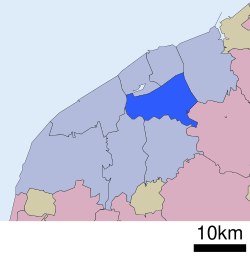
 Location of Kōnan-ku in Niigata City |
|
| Coordinates: 37°52′3.5″N 139°5′38.5″E / 37.867639°N 139.094028°E | |
| Country | Japan |
| Region | Kōshin'etsu, Hokuriku (Chūbu) |
| Prefecture | Niigata |
| City | Niigata |
| Area | |
| • Total | 75.42 km2 (29.12 sq mi) |
| Population (June 1, 2016) | |
| • Total | 68,867 |
| • Density | 913/km2 (2,360/sq mi) |
| Time zone | Japan Standard Time (UTC+9) |
| Address | 3-4-5 Izumi-Chō, Kōnan-ku, Niigata-shi, Niigata-ken 950-0195 |
| Phone number | 025-383-1000 |
| Website | www |
Kōnan-ku (江南区 Kōnan-ku?) is one of the eight wards of Niigata City, Niigata Prefecture, in the Hokuriku region of Japan. As of 1 June 2016[update], the ward had an estimated population of 68,867 and a population density of 913 persons per km². Its total area was 75.42 square kilometres (29.12 sq mi).
Kōnan-ku is located in an inland region of north-central Niigata Prefecture, near the centre of Niigata City, directly south of the central Chūō-ku. The ward is bordered by Agano River, Koagano River, Shinano River, and the Nihonkai-Tōhoku Expressway.
The area of present-day Kōnan-ku was part of ancient Echigo Province. The modern town of Kameda and the village of Yokogoshi were established on April 1, 1889 within Nakakanbara District, Niigata with the establishment of the municipalities system..
Yokogoshi was raised to town status on November 1, 1996. The city of Niigata annexed Kameda and Yokogoshi on March 21, 2005. Niigata became a government-designated city on April 1, 2007 and was divided into wards, with the new Kōnan Ward consisting of the former town of Kameda, village of Yokogoshi, and the Sonoki (曽野木?), Ryokawa (両川?) and Oeyama (大江山?) neighbourhoods of southern Niigata City.
...
Wikipedia

