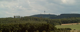
Köterberg
| Köterberg | |
|---|---|

Köterberg, north side
|
|
| Highest point | |
| Elevation | 495.8 m above sea level (NN) (1,627 ft) |
| Prominence | 289 metres (948 ft) |
| Coordinates | 51°51′20″N 9°19′30″E / 51.85556°N 9.325°ECoordinates: 51°51′20″N 9°19′30″E / 51.85556°N 9.325°E |
| Geography | |
|
|
|
| Parent range | Lippe Uplands |
The Köterberg, at 495.8 m (1,627 ft) above sea level, is the highest hill in the Lippe Uplands and lies on the state border between North Rhine-Westphalia and Lower Saxony in North Germany. On its northern slopes is the village of Köterberg.
The Köterberg is located in the centre of the Weser Uplands, towering high above the surrounding land northwest of the town of Höxter and south-southeast of Lügde within whose municipal area its summit lies.
Its peak and much of the crest lie within North Rhine-Westphalia. Only a very narrow tongue of land belongs to Lower Saxony, albeit reaching to the summit with its lower reaches lying mainly within the valley of a stream. At the western end of this strip of land the districts of Lippe, Höxter and Holzminden meet at the summit.
In the German Main Triangulation Network (Deutsches Hauptdreiecksnetz or DHDN) the Köterberg is a major triangulation station with the name Lügde, Köterberg. The area of the summit is only wooded to the north which is why the hill is easy to recognise from afar and offers good views (see below).
The Köterberg is part of the Lippe Uplands a region whose basis is formed by Mesozoic strata of Muschelkalk and Keuper. The hills itself is built on sandstones and marls of the Upper Keuper.
The Köterberg was already being mentioned in Lippe's boundary deeds in the 16th century. The Brothers Grimm called it the Götzenberg in their German Legends (Nos. 9, 20), because it was here that folk prayed to the gods of the heath. The Köterberg was also the setting for their fairy tale The Three Little Birds. Between 1796 and 1801 Karl Ludwig von Lecoq incorporated the Keutersberg as a triangulation point in his military-topographical surveys.
...
Wikipedia

