Königsbronn
| Königsbronn | ||
|---|---|---|

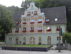
Town hall
|
||
|
||
| Coordinates: 48°44′34″N 10°6′49″E / 48.74278°N 10.11361°ECoordinates: 48°44′34″N 10°6′49″E / 48.74278°N 10.11361°E | ||
| Country | Germany | |
| State | Baden-Württemberg | |
| Admin. region | Stuttgart | |
| District | Heidenheim | |
| Government | ||
| • Mayor | Michael Stütz | |
| Area | ||
| • Total | 45.46 km2 (17.55 sq mi) | |
| Elevation | 498 m (1,634 ft) | |
| Population (2015-12-31) | ||
| • Total | 7,142 | |
| • Density | 160/km2 (410/sq mi) | |
| Time zone | CET/CEST (UTC+1/+2) | |
| Postal codes | 89551 | |
| Dialling codes | 07328 | |
| Vehicle registration | HDH | |
| Website | www.koenigsbronn.de | |
Königsbronn is a municipality in the district of Heidenheim in Baden-Württemberg in southern Germany. Königsbronn (Koenigsbronn) as an administrative community also includes the villages of Itzelberg, Ochsenberg and Zang. It lies in the Brenz valley within the hills of the Swabian Jura, a landscape shaped by karst (limestone). A spring near the town center is the source of the Brenz, a tributary of the Danube.
The Brenz pot Königsbronn lies at the eastern end of the Swabian Jura, the so-called Ostalb. The main town is like the suburb in Itzelberg Brenztal while the higher-lying suburb Zang on the west of the valley Albuch and Ochsenberg lying on the Härtsfeld east of the valley. In Königsbronn springs the Brenz, which opens at Lauingen into the Danube. North of the village on the border with neighboring city Oberkochen runs the European watershed separating the drainage areas towards the Rhine and the North Sea from the drainage area to the Danube and Black Sea. Geologically Königsbronn marked by the karst landscape of the Swabian Alb, on the limestone cliffs and caves and springs in the porous limestone (Jura) are characteristic.
The municipality Königsbronn with the formerly independent municipalities Itzelberg, Ochsenberg and Zang includes eleven villages, hamlets, farms and houses. The municipality area of Königsbronn (December 31, 1970) included the courtyards Brenzelhof, Seegartenhof, Stürzelhof, Zahnberg, Ziegelhütte and Birkach and the dialed villages Baumgarten, Spichtsol, Springen, Steinhürn, Utzemannsweiler, Wichartsberge and Herwartstein. To Ochsenberg and Zang then belonged only each the eponymous village, to Zang the dialed villages Kerbenhof, Hermann Weiler and Strut.
There is some evidence that the area was first populated in the stone age.
The foundations of a castle of the early Middle Ages possibly erected around 1000 AD on the site of an even earlier castle, of robber-knights, as it is being told can be found on the rock Herwartstein overlooking the valley, which was allegedly destroyed by the son of the emperor of Holy Roman Empire of mediaeval Germany.
Below, in the valley, a hamlet called "Springen" was formed.
In 1303, a monastery was founded (and allegedly erected with stones from the destroyed castle) for Cistercian monks. It was to become one of the most influential and wealthiest monasteries in Southern Germany. The place was renamed "Königsbronn" which means "Kings's Spring".
...
Wikipedia


