Königsau
| Königsau | ||
|---|---|---|
 |
||
|
||
| Coordinates: 49°51′24″N 07°29′18″E / 49.85667°N 7.48833°ECoordinates: 49°51′24″N 07°29′18″E / 49.85667°N 7.48833°E | ||
| Country | Germany | |
| State | Rhineland-Palatinate | |
| District | Bad Kreuznach | |
| Municipal assoc. | Kirn-Land | |
| Government | ||
| • Mayor | Heinrich Riegel | |
| Area | ||
| • Total | 2.02 km2 (0.78 sq mi) | |
| Elevation | 240 m (790 ft) | |
| Population (2015-12-31) | ||
| • Total | 64 | |
| • Density | 32/km2 (82/sq mi) | |
| Time zone | CET/CEST (UTC+1/+2) | |
| Postal codes | 55606 | |
| Dialling codes | 06765 | |
| Vehicle registration | KH | |
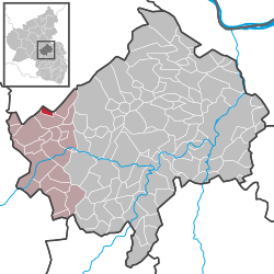
Königsau is an Ortsgemeinde – a municipality belonging to a Verbandsgemeinde, a kind of collective municipality – in the Bad Kreuznach district in Rhineland-Palatinate, Germany. It belongs to the Verbandsgemeinde of Kirn-Land, whose seat is in the town of Kirn, although this lies outside the Verbandsgemeinde.
Königsau lies in a dale in the southern Hunsrück at the edge of the Soonwald and Lützelsoon. The Kellenbach flows through the village.
Clockwise from the north, Königsau’s neighbours are the municipalities of Henau, Kellenbach, Schlierschied and – at one point only – Gehlweiler. Of these, only Kellenbach likewise lies within the Bad Kreuznach district. All the others lie in the neighbouring Rhein-Hunsrück-Kreis.
In 1325, Königsau had its first documentary mention as Kunigesauwe. Later spellings of the name, in modern times, render it Königß Auen (1601) or Kinzau (1766), the latter of which is preserved to this day in the name for the village used in the local speech, “Kinze”. The mediaeval name goes back to the Old High German cuning (meaning the same as and cognate with the English word “king”; it is König in Modern High German), which has led to the conclusion that the Königsau-Kellenbach area was once a royal or Imperial estate. Fitting this interpretation would be the Lords of Stein (Steinkallenfels), who exercised jurisdiction as Imperial ministeriales at the high court of Kellenbach. In 1325, Baldwin, Prince-Archbishop-Elector of Trier, acquired from the knight Sir Friedrich of Steinkallenfels shares of the holdings and rights that he held in Königsau and Schwarzerden and had split off from the landholds owned by Count Johann of Sponheim. In 1334, the Archbishop bought, among other things, a mill complex in Königsau, with which his successor Bohemond II of Trier enfeoffed Sir Tilmann of Stein – of the same knightly house – who was also the builder of Castle Wartenstein. In the time that followed, the Archbishops of Trier further enfeoffed various families of the lower nobility, such as the families von Elz, von Rüdesheim and von der Leyen, and the Vögte of Hunolstein, with the Trier landholds and rights in Königsau. It is, however, unclear who held sway over Königsau in the 17th and 18th centuries. Although Trier state law prevailed in Königsau, sovereignty thereover was disputable, for, on the one hand, the Electorate of Trier claimed it for itself, whereas on the other hand, the Baron of Warsberg viewed the village as an allodial, Imperial, knightly landhold. Königsau was furthermore part of the court of Kellenbach, which was subject to the Sponheim Amt of Kirchberg. In 1708, this Amt was transferred to the Margrave of Baden in the wake of the division of the “Further” County of Sponheim. The tangle of rights and allegiances to various lords during the time of the old empire was swept aside when, beginning in the years 1792-1794, the Revolutionary French overran the German lands on the Rhine’s left bank and occupied them, eventually placing the region under a central administration in 1798. Königsau and Kellenbach belonged as of roughly 1800 to the Mairie (“Mayoralty”) of Kirn in the Arrondissement of Simmern, in which it remained (albeit under other terminology than “Arrondissement”) until 1969. In the course of administrative restructuring in Rhineland-Palatinate, Königsau and Kellenbach were grouped into the new Verbandsgemeinde of Kirn-Land on 8 November 1970.
...
Wikipedia


