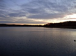
Kölpinsee (Mecklenburg)
| Kölpinsee | |
|---|---|
 |
|
| Location | Mecklenburgische Seenplatte, Mecklenburg-Vorpommern |
| Coordinates | 53°30′3″N 12°34′50″E / 53.50083°N 12.58056°ECoordinates: 53°30′3″N 12°34′50″E / 53.50083°N 12.58056°E |
| Primary inflows | Elde |
| Primary outflows | Elde |
| Basin countries | Germany |
| Surface area | 20.29 km2 (7.83 sq mi) |
| Average depth | 3.5 m (11 ft) |
| Max. depth | 30 m (98 ft) |
| Surface elevation | 62.1 m (204 ft) |
Kölpinsee is a lake in the Mecklenburgische Seenplatte district in Mecklenburg-Vorpommern, Germany. At an elevation of 62.1 metres (204 ft), its surface area is 20.29 square kilometres (7.83 sq mi).
The marshy shore of the lake was the probable site of the crash of Avro Lancaster Flight DV202 in August 1943.
...
Wikipedia
