Jungfraujoch
| Jungfraujoch | |
|---|---|

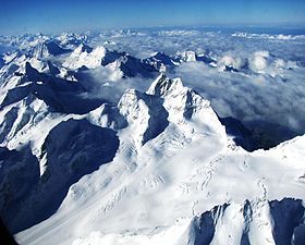
The Bernese Alps with Jungfrau in the middle, and Jungfraujoch, its saddle, to the right, and the Jungfraufirn; as seen from east
|
|
| Highest point | |
| Elevation | 3,466 m (11,371 ft) |
| Coordinates | 46°32′51″N 7°58′45″E / 46.54750°N 7.97917°ECoordinates: 46°32′51″N 7°58′45″E / 46.54750°N 7.97917°E |
| Naming | |
| Translation | Virgin Yoke (German) |
| Geography | |
| Country | Switzerland |
| Cantons | Bern and Valais |
| Parent range | Bernese Alps |
| Topo map | Swiss Federal Office for Topography - swisstopo |
Jungfraujoch is a notable saddle in the Bernese Alps, connecting the two four-thousander peaks Jungfrau and Mönch, at an elevation of 3,466 metres (11,371 ft) above sea level. It is a glacier saddle, on the upper snows of the Aletsch Glacier, and part of the Jungfrau-Aletsch area, situated on the boundary between the cantons of Bern and Valais, halfway between Interlaken and Fiesch.
Since 1912, the Jungfraujoch has been accessible to tourists by the Jungfrau line, a railway from Interlaken and Kleine Scheidegg, running partly underground through a tunnel through the Eiger and Mönch. The Jungfraujoch railway station, at an elevation of 3,454 metres (11,332 ft) is the highest in Europe. It lies east of the saddle, below the Sphinx station, and is connected to the Top of Europe building, which includes several panoramic restaurants and a post office. Several tunnels lead outside, where secured hiking trails on the crevassed glacier can be followed, in particular to the Mönchsjoch Hut.
The Sphinx Observatory, one of the highest astronomical observatories in the world, provides an additional viewing platform at a height of 3,572 metres (11,719 ft). It can be reached by an elevator from the Jungfraujoch. The observatory houses one of the Global Atmosphere Watch's atmospheric research stations. The Jungfraujoch radio relay station, which is not accessible to the public, is installed west of the Jungfraujoch, on the Jungfrau ridge. It is Europe's highest radio relay station.
...
Wikipedia

