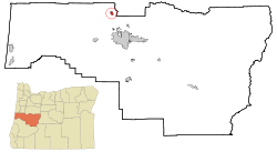
Junction City, Oregon
| Junction City, Oregon | |
|---|---|
| City | |
 Location in Oregon |
|
| Coordinates: 44°13′14″N 123°12′15″W / 44.22056°N 123.20417°WCoordinates: 44°13′14″N 123°12′15″W / 44.22056°N 123.20417°W | |
| Country | United States |
| State | Oregon |
| County | Lane |
| Incorporated | 1872 |
| Government | |
| • Mayor | Mike Cahill |
| Area | |
| • Total | 2.36 sq mi (6.11 km2) |
| • Land | 2.36 sq mi (6.11 km2) |
| • Water | 0 sq mi (0 km2) |
| Elevation | 325 ft (99.1 m) |
| Population (2010) | |
| • Total | 5,392 |
| • Estimate (2012) | 5,552 |
| • Density | 2,284.7/sq mi (882.1/km2) |
| Time zone | Pacific (UTC-8) |
| • Summer (DST) | Pacific (UTC-7) |
| ZIP code | 97448 |
| Area code(s) | 541 |
| FIPS code | 41-38000 |
| GNIS feature ID | 1166668 |
| Website | www.junctioncityoregon.gov |
Junction City is a city in Lane County, Oregon, United States. Its population was 5,392 at the 2010 census.
In the 1870s, Junction City was named by railroad magnate Ben Holladay, who decided this would be where the rail line on the east side of the Willamette Valley would meet the rail line on the west side. The westside line, however, was not built according to plan, although Junction City later was where the two main branches of U.S. Route 99 (which divided in Portland) would rejoin. The city was incorporated in 1872.
Junction City gained media attention from major outlets such as CNN, Fox News, and The Today Show in 2003, when a number of local men posed in the nude for "The Men of the Long Tom Grange Calendar" to raise money for the local school district. The project raised over $265,000 for local schools and brought national attention to the issue of school funding.
According to the United States Census Bureau, the city has a total area of 2.36 square miles (6.11 km2), all of it land.
This region experiences warm (but not hot) and dry summers, with no average monthly temperatures above 71.6 °F. According to the Köppen Climate Classification system, Junction City has a warm-summer Mediterranean climate, abbreviated "Csb" on climate maps.
As of the census of 2010, there were 5,392 people, 2,184 households, and 1,394 families residing in the city. The population density was 2,284.7 inhabitants per square mile (882.1/km2). There were 2,323 housing units at an average density of 984.3 per square mile (380.0/km2). The racial makeup of the city was 90.4% White, 0.7% African American, 1.3% Native American, 0.6% Asian, 0.1% Pacific Islander, 3.7% from other races, and 3.2% from two or more races. Hispanic or Latino of any race were 9.0% of the population.
...
Wikipedia
