Junín Department, Peru
| Junín Region | ||
|---|---|---|
| Region | ||

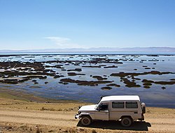
Partial view of Lake Junin
|
||
|
||
 Location of the Junín Region in Peru |
||
| Coordinates: 11°29′S 74°59′W / 11.48°S 74.98°WCoordinates: 11°29′S 74°59′W / 11.48°S 74.98°W | ||
| Country | Peru | |
| Subdivisions | 9 provinces and 123 districts | |
| Capital | Huancayo | |
| Government | ||
| • President | Vladimir Cerrón Rojas | |
| Area | ||
| • Total | 44,197.23 km2 (17,064.65 sq mi) | |
| Highest elevation | 4,818 m (15,807 ft) | |
| Population (2004 estimate) | ||
| • Total | 1,274,781 | |
| • Density | 29/km2 (75/sq mi) | |
| UBIGEO | 12 | |
| Dialing code | 064 | |
| ISO 3166 code | PE-JUN | |
| Principal resources | Potato, coffee, fruit, silver, zinc, lead. | |
| Website | www.regionjunin.gob.pe | |
Junín is a region in the central highlands and westernmost Amazonia of Peru. Its capital is Huancayo.
The region has a very heterogeneous topography. The western range located near the border with the Lima Region, has snowy and ice-covered peaks. On the east, there are high glacier valleys which end up in high plateaus (Altiplano). Among them is the Junín Plateau that is located between the cities of La Oroya and Cerro de Pasco.
The Mantaro Valley becomes wider before Jauja up to the limit with the Huancavelica Region. This area concentrates a large share of the region's population. Towards the east, near the jungle, there is an abundance of narrow and deep canyons, with highly inclined hillsides, covered by woods under low-lying clouds.
The Waytapallana mountain range is located in the south central area of the region. This range holds a great fault which is the reason earthquakes happen in the area. The upper jungle, with valleys of great length, modelled by the Tulumayu, Pawqartampu, Perené and Ene rivers, is located on the eastern side of the region.
Lake Junin, the largest lake entirely within Peru, is located in the region, except for its northernmost tip which belongs to the Pasco Region.
Junín Region is also home to Mount Toromocho.
...
Wikipedia
