Juab County
| Juab County, Utah | |
|---|---|

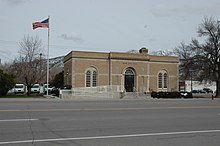
U.S. Post Office in Nephi
|
|
 Location in the U.S. state of Utah |
|
 Utah's location in the U.S. |
|
| Founded | 1852 |
| Named for | Native American word for valley |
| Seat | Nephi |
| Largest city | Nephi |
| Area | |
| • Total | 3,406 sq mi (8,821 km2) |
| • Land | 3,392 sq mi (8,785 km2) |
| • Water | 14 sq mi (36 km2), 0.4% |
| Population (est.) | |
| • (2015) | 10,594 |
| • Density | 3.0/sq mi (1/km²) |
| Congressional district | 2nd |
| Time zone | Mountain: UTC-7/-6 |
| Website | www |
Juab County /ˈdʒuːæb/ is a county located in the U.S. state of Utah. As of the 2010 census, the population was 10,246. Its county seat and largest city is Nephi. The county was named from a Native American word meaning thirsty valley, or possibly only valley.
Juab County is part of the Provo–Orem, UT Metropolitan Statistical Area, which is also included in the Salt Lake City-Provo-Orem, UT Combined Statistical Area.
According to the U.S. Census Bureau, the county has a total area of 3,406 square miles (8,820 km2), of which 3,392 square miles (8,790 km2) is land and 14 square miles (36 km2) (0.4%) is water.
As of July 1, 2015, the US Census Bureau estimates that there were 10,594 people, 3,557 housing units, and 3,557 housing units in the county. The population density was 3 people per square mile (1/km²). There were 3,066 households. The racial makeup of the county was 96.4% White, 0.4% Black or African American, 1.0% Native American, 0.4% Asian, 0.2% Pacific Islander, and 1.5% from two or more races. 4.7% of the population were Hispanic or Latino of any race.
...
Wikipedia
