Juíz de Fora
| Juiz de Fora | |||
|---|---|---|---|
| Municipality | |||
 |
|||
|
|||
| Nickname(s): JF | |||
| Motto: Pro Patria et Urbe | |||
 |
|||
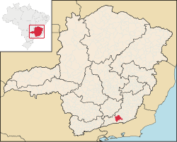
| Location in Juiz de Fora, Minas Gerais, Brazil | |||
| Coordinates: 21°45′43″S 43°20′58″W / 21.76194°S 43.34944°WCoordinates: 21°45′43″S 43°20′58″W / 21.76194°S 43.34944°W | |||
| Country | Brazil | ||
| Region | Southeast | ||
| State | Minas Gerais | ||
| Incorporated | 30 May 1850 | ||
| Government | |||
| • Mayor | Bruno Siqueira (PMDB) | ||
| Area | |||
| • Total | 1,436 km2 (554 sq mi) | ||
| Elevation | 678 m (2,224 ft) | ||
| Population (2015) | |||
| • Total | 555,284 | ||
| • Density | 359.59/km2 (931.3/sq mi) | ||
| Time zone | UTC-3 (UTC-3) | ||
| • Summer (DST) | UTC-2 (UTC-2) | ||
| Postal Code | 36000-000 | ||
| Area code(s) | +55 32 | ||
| Demonym | juiz-forano | ||
| Website | Juiz de Fora, Minas Gerais | ||
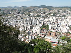
Juiz de Fora (Portuguese pronunciation: [ˈʒwiʒ dʒi ˈfɔɾɐ], Outsider Judge), also known as J.F., is a city in the southeastern Brazilian state of Minas Gerais, approximately 40 kilometres (25 mi) from the state border with Rio de Janeiro. According to 2014 estimates the current population is about 550,710 inhabitants. The geographical area of the municipality is 1,437 km2 (555 sq mi).
The city's location was a key factor in its economic and demographic development since it is situated between the three most important financial and economic metropolises of southeast Brazil (and also the three largest urban sprawls of the country): Rio de Janeiro (189 km (117 mi)), Belo Horizonte (260 km (160 mi)) and São Paulo (486 km (302 mi)). Major highways connect Juiz de Fora with these three metropolitan areas, the most important being the BR 040 which connects Brasília with Rio de Janeiro via Belo Horizonte. The city is built on the Paraibuna, a major tributary of the Paraíba do Sul river.
The origins of Juiz de Fora can be traced back to the beginnings of the 18th century, when the Caminho Novo (New Way) road was opened linking Rio de Janeiro to the gold rush area of Minas Gerais around Vila Rica (now Ouro Preto). The region was covered with dense forest (hence its name; "Zona da Mata", Forest Zone). Despite the opening of the new route the area remained largely uninhabited and most of its scarce settlement was centered on the road itself. The first permanent inhabitants of the municipality were merchants and farmers who supplied the travelers' needs on the long road between the coast and the gold region.
...
Wikipedia


