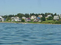
Jonesport, Maine
| Jonesport, Maine | ||
|---|---|---|
| Town | ||
 |
||
|
||
| Location within the state of Maine | ||
| Coordinates: 44°33′17″N 67°34′41″W / 44.55472°N 67.57806°W | ||
| Country | United States | |
| State | Maine | |
| County | Washington | |
| Incorporated | February 3, 1832 | |
| Area | ||
| • Total | 100.35 sq mi (259.91 km2) | |
| • Land | 28.51 sq mi (73.84 km2) | |
| • Water | 71.84 sq mi (186.06 km2) | |
| Elevation | 23 ft (7 m) | |
| Population (2010) | ||
| • Total | 1,370 | |
| • Estimate (2012) | 1,359 | |
| • Density | 48.1/sq mi (18.6/km2) | |
| Time zone | Eastern (EST) (UTC-5) | |
| • Summer (DST) | EDT (UTC-4) | |
| ZIP code | 04649 | |
| Area code(s) | 207 | |
| FIPS code | 23-36010 | |
| GNIS feature ID | 0582537 | |
Jonesport is a town in Washington County, Maine, United States. The population was 1,370 at the 2010 census. Jonesport is a fishing and lobstering town.
Settled before the American Revolution, this was part of a grant of 48,160 acres (194.9 km2) made by the Massachusetts General Court in 1789 to John C. Jones and others. It was incorporated on March 4, 1809, as Jonesborough. On February 3, 1832, a portion of Jonesborough was set off and incorporated as Jones' Port. Then a portion of Jonesport was set off and incorporated on April 7, 1925, as the island town of Beals, accessible by bridge, built in 1958, across the Moosabec Reach.
Located on a peninsula 6 miles (9.7 km) out in the Gulf of Maine, the town's principal industries are fishing, boat building, harvesting blueberries, and tourist services. Jonesport includes many uninhabited islands which provide nesting areas for eider, cormorants, seagulls, razorbills, guillemots, loons, black scoters, grebes and eagles. There are two nature preserves: Western Brothers Island and the Great Wass Archipelago (which includes Great Wass Island), the latter shared with the town of Beals.
...
Wikipedia


