Johnson County, Kentucky
| Johnson County, Kentucky | |
|---|---|

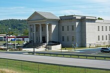
Johnson County Judicial Center in Paintsville
|
|
 Location in the U.S. state of Kentucky |
|
 Kentucky's location in the U.S. |
|
| Founded | February 24, 1843 |
| Named for | Richard Mentor Johnson |
| Seat | Paintsville |
| Largest city | Paintsville |
| Area | |
| • Total | 264 sq mi (684 km2) |
| • Land | 262 sq mi (679 km2) |
| • Water | 2.2 sq mi (6 km2), 0.8% |
| Population | |
| • (2010) | 23,356 |
| • Density | 89/sq mi (34/km²) |
| Congressional district | 5th |
| Time zone | Eastern: UTC-5/-4 |
| Website | www |
Johnson County is a county located in the U.S. state of Kentucky. As of the 2010 census, the population was 23,356. Its county seat is Paintsville. The county was formed in 1843 and named for Richard Mentor Johnson, War of 1812 general, United States Representative, Senator, and Vice President of the United States. Johnson County is classified as a moist county, which is a county in which alcohol sales are not allowed (a dry county), but containing a "wet" city, in this case Paintsville, where alcoholic beverage sales are allowed.
Johnson County was formed on February 24, 1843 by the Kentucky General Assembly from land given by Floyd, Lawrence, and Morgan counties. At that time, its county seat of Paintsville had already been a chartered city for nine years. Homes had been built in Paintsville as early as the 1810s.
Many of the families at the beginning of Johnson County's formation were of Scottish, Irish, English, or German descent. Also, a fact lost to most historians is the large population of French Huguenots who were confused as English because they fled via England en route to the United States. Many of these settlers migrated from North Carolina, Pennsylvania, and Virginia following their participation in the Revolutionary War.
...
Wikipedia
