Jiang'an District
|
Jiang'an 江岸区 |
||||||||||||||||||||||||||||||||||||
|---|---|---|---|---|---|---|---|---|---|---|---|---|---|---|---|---|---|---|---|---|---|---|---|---|---|---|---|---|---|---|---|---|---|---|---|---|
| District | ||||||||||||||||||||||||||||||||||||

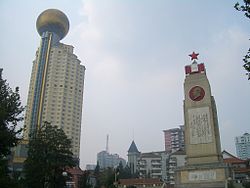
02.16 Flood Memorial in Riverside Park (沿江公园)
|
||||||||||||||||||||||||||||||||||||
| Location in Hubei | ||||||||||||||||||||||||||||||||||||
| Coordinates: 30°38′11″N 114°19′49″E / 30.6365°N 114.3304°ECoordinates: 30°38′11″N 114°19′49″E / 30.6365°N 114.3304°E | ||||||||||||||||||||||||||||||||||||
| Country | People's Republic of China | |||||||||||||||||||||||||||||||||||
| Province | Hubei | |||||||||||||||||||||||||||||||||||
| Sub-provincial city | Wuhan | |||||||||||||||||||||||||||||||||||
| Area | ||||||||||||||||||||||||||||||||||||
| • Total | 64.24 km2 (24.80 sq mi) | |||||||||||||||||||||||||||||||||||
| Population (2010) | ||||||||||||||||||||||||||||||||||||
| • Total | 895,635 | |||||||||||||||||||||||||||||||||||
| • Density | 13,942/km2 (36,110/sq mi) | |||||||||||||||||||||||||||||||||||
| Time zone | China Standard (UTC+8) | |||||||||||||||||||||||||||||||||||
| Wuhan district map |
|
|||||||||||||||||||||||||||||||||||
| Website | jiangan |
|||||||||||||||||||||||||||||||||||
Jiang'an District (simplified Chinese: 江岸区; traditional Chinese: 江岸區; pinyin: Jiāng'àn qū; literally: "river bank") forms part of the urban core of and is one of 13 districts of Wuhan, the capital of Hubei province, People's Republic of China.
Jiang'an Lim district is located on the Yangtze's left (northwestern) shore, and includes the northeastern half of the former Hankou city (northeast, i.e. downstream, of Jianghan Rd.). On the left bank of the Yangtze, it borders Huangpi to the north, Jianghan to the southwest, and Dongxihu to the west; on the opposite bank it borders Hongshan, Wuchang, and Qingshan.
...
Wikipedia


