Jet, Oklahoma
| Jet, Oklahoma | |
|---|---|
| Town | |

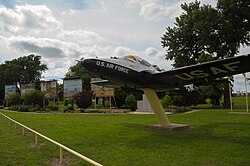
Cessna T-37B Tweet (serial # 56-3563) on display at the Jet Lions Memorial Park.
|
|
| Motto(s): Goose Hunting Capital of Oklahoma | |
|
Location of Jet within Alfalfa County in the state of Oklahoma.
|
|
| Coordinates: 36°39′58″N 98°10′52″W / 36.66611°N 98.18111°WCoordinates: 36°39′58″N 98°10′52″W / 36.66611°N 98.18111°W | |
| Country | United States |
| State | Oklahoma |
| County | Alfalfa |
| Area | |
| • Total | 0.3 sq mi (0.8 km2) |
| • Land | 0.3 sq mi (0.8 km2) |
| • Water | 0.0 sq mi (0.0 km2) |
| Elevation | 1,243 ft (379 m) |
| Population (2010) | |
| • Total | 213 |
| • Estimate (2015) | 225 |
| • Density | 684/sq mi (264.0/km2) |
| Time zone | Central (CST) (UTC-6) |
| • Summer (DST) | CDT (UTC-5) |
| ZIP code | 73749 |
| Area code(s) | 580 |
| FIPS code | 40-38000 |
| GNIS feature ID | 1094222 |
Jet is a town in Alfalfa County, Oklahoma, United States. The population was 213 at the 2010 census.
The community of Jet was founded by six unmarried brothers: Joseph, Trigg, Newt, Warner, John, and Richard Jett, who established homesteads in the former Cherokee Outlet, shortly after its opening to settlement by non-Indians. The brothers erected buildings and opened a general store on Richard's land. The Jet post office was established in 1894, with Warner Jett as the first postmaster. The community grew into a small town, and Jet incorporated in 1900.
The Frisco Townsite Company, owned by the Denver, Enid and Gulf Railroad (DE&G) (acquired by the Atchison, Topeka and Santa Fe Railway in 1907), surveyed a plot of land about 2 miles (3.2 km) west of the original town and relocated Jet during 1905-1906. By August, 1907, the town had Baptist, Mennonite, Methodist, and Presbyterian churches in addition to seven general stores, two banks, two hotels, two grain elevators, plus a small school under construction. At the time of statehood in 1907, Jet had a population of 213 people.
Jet is located at 36°39′58″N 98°10′52″W / 36.66611°N 98.18111°W (36.6661416, -98.1811787). It is 12 miles (19 km) east-southeast of the county seat, Cherokee.
According to the United States Census Bureau, the town has a total area of 0.3 square miles (0.78 km2), all of it land.
Jet is located at the intersection of U.S. Highway 64 and State Highway 38. This intersection is the southern terminus of SH-38.
...
Wikipedia

