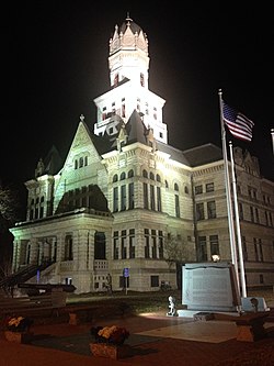
Jerseyville, Illinois
| Jerseyville | |
| City | |
|
The Jersey County Courthouse in Downtown Jerseyville, 2013
|
|
| Country | United States |
|---|---|
| State | Illinois |
| County | Jersey |
| Township | Jersey |
| Elevation | 659 ft (200.9 m) |
| Coordinates | 39°7′15″N 90°19′39″W / 39.12083°N 90.32750°WCoordinates: 39°7′15″N 90°19′39″W / 39.12083°N 90.32750°W |
| Area | 5.08 sq mi (13.2 km2) |
| - land | 5.08 sq mi (13 km2) |
| - water | 0.00 sq mi (0 km2), 0% |
| Population | 8,532 (2014) |
| Density | 1,679.5/sq mi (648.5/km2) |
| Founded | 1827 |
| - Incorporated Town | July 21, 1837 |
| - City Charter | February 21, 1867 |
| Government | City commission |
| Mayor | William Billy Russel |
| Timezone | CST (UTC-6) |
| - summer (DST) | CDT (UTC-5) |
| Postal code | 62052 |
| Area code | 618 |
|
Website: www |
|
| Jerseyville, Illinois | ||||||||||||||||||||||||||||||||||||||||||||||||||||||||||||
|---|---|---|---|---|---|---|---|---|---|---|---|---|---|---|---|---|---|---|---|---|---|---|---|---|---|---|---|---|---|---|---|---|---|---|---|---|---|---|---|---|---|---|---|---|---|---|---|---|---|---|---|---|---|---|---|---|---|---|---|---|
| Climate chart () | ||||||||||||||||||||||||||||||||||||||||||||||||||||||||||||
|
||||||||||||||||||||||||||||||||||||||||||||||||||||||||||||
|
||||||||||||||||||||||||||||||||||||||||||||||||||||||||||||
| J | F | M | A | M | J | J | A | S | O | N | D |
|
1.9
35
17
|
2
41
22
|
3.5
53
32
|
4.1
64
42
|
4
74
52
|
3.7
83
61
|
3.5
88
66
|
2.9
86
63
|
3.2
79
55
|
2.9
68
43
|
3.8
53
34
|
2.8
40
23
|
| Average max. and min. temperatures in °F | |||||||||||
| Precipitation totals in inches | |||||||||||
| Source: The Weather Channel | |||||||||||
| Metric conversion | |||||||||||
|---|---|---|---|---|---|---|---|---|---|---|---|
| J | F | M | A | M | J | J | A | S | O | N | D |
|
49
2
−8
|
51
5
−6
|
89
12
0
|
105
18
6
|
100
23
11
|
93
28
16
|
89
31
19
|
74
30
17
|
Wikipedia
...
| |||


